Chicago residents experienced a mix of weather conditions this past week, starting with a slight chance of showers and a partly sunny high near 83 degrees on Friday afternoon, according to the National Weather Service. The weather took a significant turn as severe storms brought the potential for tornadoes, strong winds, and flooding later in the evening. The forecast mentioned a 20 percent chance of showers before the storms were expected to ramp up.
As Chicagoans prepared for the possibility of turbulent weather, a tornado watch went into effect across the area. It was scheduled to last until 11 p.m. Friday but was called off before 9 p.m., NBC Chicago reported. Areas to the city's west were pegged with an "enhanced" risk level for severe storms, indicating more significant concern there. On the other side, parts of the metropolitan area were categorized as being under a "slight" risk.
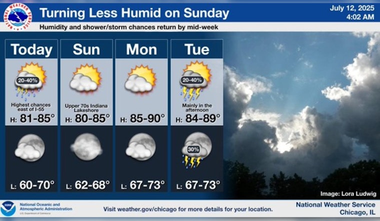
The weekend forecasts projected more agreeable conditions, with mostly sunny skies and highs climbing towards 85 on Sunday and an even warmer 90 by Monday. While Monday night was expected to be partly cloudy, the low hovered around a comfortable 73 degrees. Starting Tuesday, the chance of showers crept back into the forecast, marking the beginning of an unsettled pattern that included probabilities of showers and thunderstorms, particularly in the afternoons.
As the week progressed, the instability continued with Wednesday threatening showers and thunderstorms, potentially becoming more severe after 1 p.m. According to the forecast, these weather conditions likely followed through into the night and the next day, punctuating the city's weather landscape with bouts of precipitation and rumbles of thunder. The week was set to round off with a shift to mostly sunny skies and a high near 79 on Friday. With such rapid weather changes, Chicago residents were advised to stay alert to updates and be prepared for a spectrum of weather scenarios.


