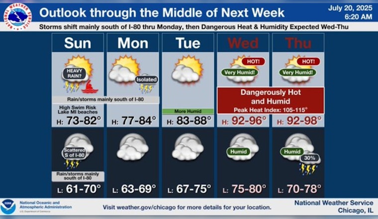
Chicago's weather pattern this coming week presents a melody of thunderstorms, heat, and intermittent relief, with meteorologists advising residents to brace for a temperamental climate ahead. According to the National Weather Service's forecast, scattered showers and thunderstorms are expected today, primarily before noon, with a high near 74 degrees and a gentle northeast wind. Tonight, the city will see mostly cloudy skies with a low around 69.
Monday's sunrise brings mostly sunny skies, with a high projected around 81 and east winds picking up to 10 mph, including gusts that could reach 15 mph. As reported by ABC7 Chicago, spotty storms will dot the area, ushering in Tuesday's hot and humid conditions, with a few more storms likely. Although hitting the high 91, sleeping through Tuesday night's warmth may prove challenging with lows around 74 degrees.
Midweek forecasts have Chicagoans feeling the heat as Wednesday's temperature is expected to feel like nearly 100 degrees, peaking at an actual high of around 93. Swinging to Thursday, the city will persist in its sultry state, staying hot and muggy with a high of 94 and a low of a mere degree cooler than the previous night at 75, offering little respite from the relentless humidity.
As the week wanes, Friday offers a semblance of hope with the possibility of isolated storms as the city experiences a high of 87 and a low of 71. Saturday finally brings "relief," with normal temperatures returning, offering Chicagoans a much-needed reprieve as highs softly reach 85 and lows settle at 72. Throughout the week, the weather pendulum swings from "mostly sunny" days to tumultuous nights threatened by scattered thunderstorms, challenging the city's denizens to remain adaptable.


