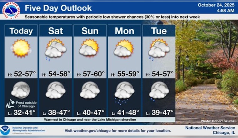
Chicagoans are set to experience a mix of sunny skies and cloud cover as the weekend progresses. Today warms the city's landscape with a high near 53 degrees, and the week will see days mostly sunny with highs wavering in the mid-50s, according to the National Weather Service. The calm before the storm, tonight's partly cloudy veil, and a low around 40 will gently give way to a 20 percent chance of showers post-1 pm Saturday.
The temperature outlook for Saturday is a seasonable mid-50s high, but things are expected to get slightly warmer on Sunday, with highs possibly reaching up to around 60 degrees. Early next week, however, Chicago may bear witness to a tangle with some minor weather disruptions. "Early next week will be mostly cloudy with a storm system approaching from the west," FOX 32 Chicago reports, adding, "It is unlikely that much rain will reach the Chicago area, but there is at least a chance for some light showers Tuesday and Wednesday." The National Weather Service forecasts a persistent 20 percent chance of showers commencing Sunday night and lingering early into the following week.
As for temperatures, they won't stray far from the norm. The National Weather Service's forecast sets them steady—highs generally in the mid to upper 50s and lows comfortably nestling in the low to mid-40s. The variety will not be through a wide range of temperatures but through intermittent sunshine and clouds rolling in and out, keeping the climate on its toes.
Moving forward, Chicago will need to keep an umbrella close, but not necessarily overhead. "There won’t be much temperature variety in the week ahead," states FOX 32 Chicago.


