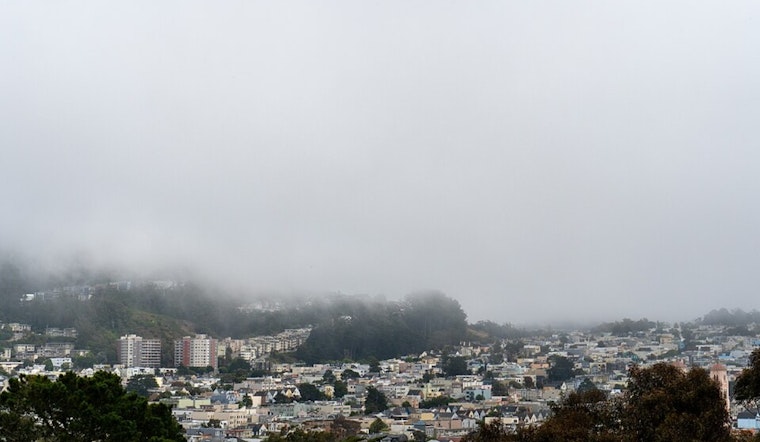
Dense fog continues to grip portions of the Bay Area this Saturday morning, with visibility dropping to a quarter mile or less in some locations as a stubborn weather pattern finally prepares to give way to much-needed rain next week.
The National Weather Service issued a Dense Fog Advisory for the North Bay Interior Valleys and East Bay Interior Valleys until 11 AM this morning. According to The Mercury News, the advisory warns of hazardous driving conditions with visibility reduced to one quarter mile or less in dense fog.
What's particularly interesting about Saturday's fog is its dual nature. Meteorologists describe it as "a tale of two fogs"—both tule fog seeping through gaps from the Central Valley and traditional advection fog moving in from coastal locations due to a southerly surge. This combination is creating what the weather service calls "below normal temperatures" in affected areas while simultaneously bringing an end to the warm, sunny afternoons the region has enjoyed over the past week.
The Persistent Tule Fog Pattern
The current fog event is part of a larger pattern that has dominated much of California since late November. According to NASA, satellite imagery shows a sprawling blanket of fog filling most of the Central Valley from Redding to Bakersfield between November 24 and December 9. The fog occasionally spilled through the Carquinez Strait toward San Francisco Bay, creating the conditions Bay Area residents have experienced in recent weeks.
Climate scientist Daniel Swain explained on his Weather West blog that the persistent ridging and stable air mass aloft has allowed extensive tule fog to form throughout the Central Valley, with frequent spillover into the North and East Bay region. This has resulted in a remarkable temperature contrast between cold areas under the fog layer and the immediately adjacent hills and mountains.
As KTVU reports, many locations in the Central Valley experienced above normal rainfall earlier in fall, leaving significant moisture close to the surface—a necessary ingredient for fog formation. The stable pattern, coupled with cold temperatures at night, allowed the fog to form and fill the Central Valley before northeast surface winds escorted it into parts of the Bay Area.
Relief on the Horizon
While fog will dominate the morning hours, forecasters say a pattern shift is coming that should finally break up the persistent low clouds. The National Weather Service indicates that wet conditions are expected to return next week, with the upper-level longwave ridge exiting to the east on Sunday and giving way to zonal flow.
According to the San Francisco Chronicle, confidence is growing that the second half of December will feature a flurry of storms from the Bay Area to the Sierra Nevada. The Climate Prediction Center predicts a 60 to 70 percent chance of above-normal precipitation in the Bay Area between December 17 and 21, with higher odds farther north.
The weather service notes that passing disturbances to the north and an increase in precipitable water will renew rain chances as early as Monday, with no clear dry day beyond that. A relatively more significant system is forecast toward the end of next week as a surface low pressure system and its attendant cold front approach the California Coast. Looking further ahead, forecasters indicate a moderate risk of heavy precipitation and high winds from December 20 through December 26.
Preparing for the Change
For those tired of the foggy, chilly conditions, the approaching pattern change should bring welcome relief—though it comes with its own preparations. The National Weather Service suggests this weekend would be a great time to clean out gutters and trim trees away from homes and power lines in anticipation of the wetter weather.
Until then, drivers navigating through this morning's fog are urged to use low-beam headlights, slow down, and leave plenty of distance between vehicles. The weather service recommends considering delaying unnecessary travel until visibilities improve, particularly in the hardest-hit interior valleys where conditions can change dramatically within just a few feet.
This extended dry spell—now at about three weeks in most areas since the last significant rainfall on November 20—has been notable but not unusual for the season. As East Bay Times reports, there have been 54 instances of dry spells lasting 24 days or more between November and March since 1849, meaning the chance of such an extended drought in any given winter is around 31 percent.
With temperatures expected to reach up to 15 degrees above normal in areas that escape the fog today, the contrast between valley and hillside conditions remains stark. But as the ridge pattern breaks down and storms begin to move in next week, the entire region should see a return to more typical December weather—complete with the rain that will finally disrupt the relentless tule fog pattern.


