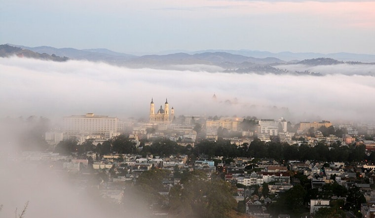
Dense fog blanketed parts of the Bay Area early Tuesday morning, creating treacherous driving conditions and forcing some commuters to crawl. Byron reported visibility of less than a quarter mile, while Napa and Petaluma airports saw similar conditions that could persist through the morning rush hour.
The fog is just one symptom of what forecasters are calling a "ridiculously resilient ridge"—a stubborn dome of high pressure that's been parked over California for nearly two weeks now. The phrase might sound whimsical, but it's actually a term coined by climate scientist Daniel Swain back in 2013 to describe the same kind of weather pattern that contributed to California's epic 2011-2017 drought. According to the National Weather Service, this particular ridge continues to dominate the forecast, keeping conditions dry and pleasant by day while trapping cold air in valleys overnight.
Why the Valleys Are Getting Foggy
Here's what's happening: the high pressure system acts like a lid, trapping cold, moist air in low-lying areas while warmer air sits above it—a temperature inversion. When that cold air reaches its saturation point overnight, you get fog. Lots of fog. The North Bay and East Bay valleys have been particularly susceptible, with morning commuters advised to allow extra time and watch for sudden visibility drops. "Early morning commuters in the North and East Bays should be prepared for sudden changes in visibility and allow extra time to reach their destinations," forecasters warned in their early morning discussion.
The good news? Once the morning fog burns off, Tuesday shapes up to be another beautiful day with clear skies and mild temperatures. Highs around the Bay Area will mostly hit the low to mid 60s, while the Central Coast could see mid 60s to low 70s. But here's the catch—temperatures are starting to cool down slightly as that stubborn ridge finally begins to weaken.
The Ridge Is Finally Breaking Down
After holding near-record strength last Wednesday, the high pressure system is slowly losing its grip. A weather system off the coast—what meteorologists call a "cut-off low"—will move down the California coastline Thursday and Friday, bringing slightly cooler air with it. Don't get too excited about rain, though. The moisture from this system will mostly stay south, clipping only southern Monterey County with maybe a 10-20% chance of light showers in the Santa Lucia Range. "No real accumulation is expected from this system as the bulk of the moisture (and rain) will be well to our south," the NWS noted.
The pattern has been remarkably persistent. As KSBW reported Monday, this "ridiculously resilient ridge" has been keeping temperatures running 5 to 15 degrees above normal for this time of year across the Central Coast. Sunday saw widespread highs in the low to upper 70s—pleasant for outdoor activities, but a reminder of just how dominant this weather pattern has been.
When Will Real Rain Return?
Here's where it gets interesting. After this week's cut-off low slides by, the ridge will rebuild over the weekend and into next week—meaning more dry weather. But there's a glimmer of hope on the horizon. Long-range forecast models are showing "high confidence" that a deep upper level trough will move into the West Coast at the end of January or beginning of February. According to the NWS, European forecast models have started gaining confidence, with "nearly every member showing at least some precipitation during that timeframe."
The timing keeps getting pushed back, though, which is typical for long-range forecasts. "There's still a wide range in timing and amounts so we'll have to see how this shapes up as it gets closer," forecasters cautioned. Translation: don't put away the umbrella permanently, but don't expect to need it this week either.
What About All That Fog?
The fog pattern looks set to continue through the week, with the potential for even more widespread fog on Thursday and Friday nights. Forecasters are leaning toward the return of low clouds (stratus) rather than dense fog at that point, but either way, visibility could be impacted during morning commutes. The marine layer is expected to deepen to around 1,000 feet starting Thursday, which would support those low clouds pushing into interior valleys. Anyone driving early in the morning should be prepared for sudden visibility drops—that means headlights on, speed down, and extra following distance.
Temperatures will stay seasonal through next week, with highs in the upper 50s to low 60s Wednesday through Monday. The interior Central Coast will buck that trend slightly, warming into the mid to upper 60s starting Saturday. Overnight lows will generally stay in the 40s, though some spots could dip into the upper 30s again starting Saturday—nothing like the freezing temperatures some areas saw earlier this month, but chilly enough to remind you it's still winter.
Good Flying Weather, Tricky Driving
For aviation, conditions look good once the morning fog clears. VFR (visual flight rules) conditions prevail at most airports, with light winds and clear skies making for smooth flying. The exceptions are those Delta-area airports dealing with Tule fog Tuesday morning, where visibility restrictions could linger into late morning. San Francisco International should see light winds with a slight northeast component through the morning, becoming variable or turning northwest by afternoon.
On the water, gentle to moderate breezes will continue across Bay Area waters early this week, with winds increasing late week to a strong breeze by Friday. A weak storm system over the eastern Pacific will generate a moderate northwest swell, promoting rough seas across the northern outer waters—nothing dramatic, but worth noting if you're planning to head out.
The Bigger Picture
This extended dry pattern is classic California: bone-dry January following a soaking early January. Remember those atmospheric rivers and record flooding around New Year's? Those filled reservoirs to healthy levels, meaning this dry spell is more welcome break than cause for alarm. But as the pattern persists, the comparison to the original "Ridiculously Resilient Ridge" of 2011-2017 becomes harder to ignore. That ridge contributed to California's worst drought in modern history—though back then, it lasted for years, not weeks.


