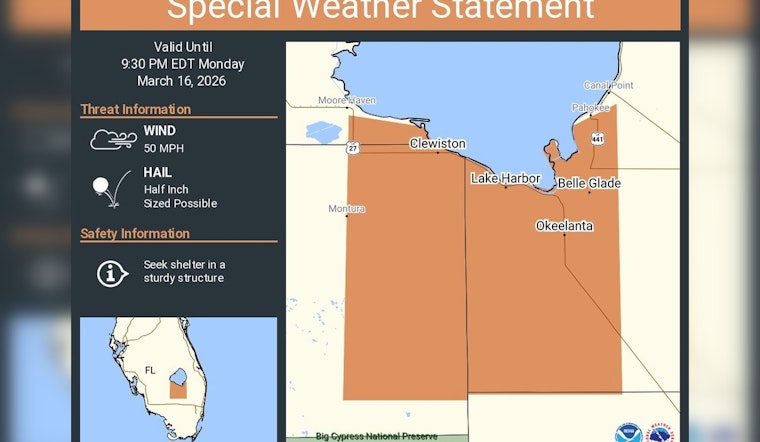
Monday night, the National Weather Service office in Miami put the Belle Glade area on notice, issuing a special weather statement for Belle Glade, Clewiston and South Bay as storms fired up around Lake Okeechobee. Forecasters warned the cells could crank out isolated hail up to a half inch in diameter and wind gusts near 50 mph, with the statement valid through 9:30 p.m. EDT. People in the path were urged to keep an eye on updates and head indoors if the weather started to turn ugly.
The Miami office pushed the alert out on X, warning of “hail up to 1/2 inch” and gusts near 50 mph, and urging anyone in the area to “seek shelter in a sturdy structure” until the statement expired. According to NWS Miami, Belle Glade, Clewiston and South Bay were highlighted as the communities most immediately at risk from the strongest cores.
A special weather statement has been issued for Belle Glade FL, Clewiston FL and South Bay FL until 9:30 PM EDT https://t.co/tLppB6PI8u
— NWS Miami (@NWSMiami) March 17, 2026
Where the Threat Was Centered
Weather Underground’s alert summary echoed the National Weather Service list, flagging Belle Glade, Pahokee and South Bay as communities under the special statement. As shown by Weather Underground, radar-indicated storm cells were marching across inland Palm Beach County and neighboring Hendry County around the time the notice went live.
How to Stay Safe
For these quick-hitting but punchy storms, NWS guidance stays simple: get inside a sturdy building, skip the car or mobile home if you can, and keep clear of windows while strong gusts are in play. For any upgraded alerts, including possible warnings if storms intensify, the Miami forecast office advises checking its website and social channels for the latest products, watches and warnings, according to NWS Miami.
What Is Driving the Storms
The storm cells were being nudged along by a cold front sliding across the Florida Peninsula Monday night, a familiar setup for late-winter thunderstorms in South Florida. The activity slots into a larger March system that has produced severe weather across portions of the eastern United States; see Wikipedia for broader context on the March 13 to 17 North American storm complex.
Residents along the Glades corridor are encouraged to keep tabs on local forecasts, as conditions can shift quickly and additional warnings may follow if storms strengthen. For immediate alerts and short-fuse updates, follow NWS Miami or the office’s feed on X.


