A proposal known as the Bay Skyway would knit together a string of existing and new multiuse paths so that, in theory, someone could walk or bike from Lake Merritt in Oakland all the way to San Francisco’s Ferry Building. The vision bundles elevated connections in West Oakland, a multi-use route across Yerba Buena Island, and a future walking and biking path on the Bay Bridge’s western span. Planners and advocates say the route could change how people handle short transbay trips, although it comes with a steep price tag and a long list of unresolved design and permitting issues.
What the Bay Skyway Would Do
The Bay Skyway is being advanced as a connected program of projects that would extend the Bay Bridge East Span path westward to Treasure Island and eastward into West Oakland, creating a continuous corridor for walking, biking and micromobility across the bay. The concept ties together the West Oakland Link and the Yerba Buena Island Multi-Use Pathway with a longer-term western-span path that would finally complete a shore-to-shore route. As outlined by the Metropolitan Transportation Commission, some interim segments are already in design and regional agencies are doing public outreach to shape what comes next.
Pieces, Schedule and Transit Links
The first "Multimodal" phase focuses on the West Oakland Link and the Yerba Buena Island Multi-Use Pathway, which are meant to feed into a Treasure Island transit hub where people could transfer to ferries or express buses. Agency schedules put parts of the Yerba Buena Island work, along with related road and bridge upgrades, into the 2027 to 2029 construction window, with staged openings for temporary connectors along the way. These segment plans and timelines are laid out by the San Francisco County Transportation Authority, which is leading the Yerba Buena Island multiuse pathway effort.
Price Tag and Where the Money Stands
Public reporting and project staff estimates put the full Bay Skyway, including a walking and biking deck on the Bay Bridge’s western span, at roughly $700 million, with only about $200 million identified so far and a sizable funding gap still to close. State materials prepared for recent grant applications list a $233.5 million total for the Multimodal Bay Skyway phase, reflecting just one piece of the larger package planners are trying to assemble. Those funding figures and the remaining shortfall are described in the California Transportation Commission’s staff recommendations.
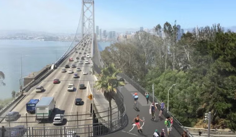
Design Trade-offs and the Environmental Test
Transportation experts and reporters note that the western-span section comes with serious engineering headaches: seismic safety, wind loads, maintenance access and clearance for ships all factor into whether, and how, a pedestrian and bike deck could be attached to the existing structure. Agencies also say state and federal environmental reviews will be required to examine air quality, noise and safety impacts for people traveling right next to heavy vehicle traffic. Those technical hurdles, along with the timing of the environmental review process, have been highlighted by the San Francisco Chronicle.
What’s Next for Riders and Funders
Agency staff say groundwork for some interim segments could start as soon as 2027, but the full shore-to-shore vision depends on both closing the remaining funding gap and getting through environmental review. Local advocates are already trying to keep momentum up: The Oaklandside reports that Bike East Bay organizers have planned an April 25 Trails Day ride to push for continued investment in the Bay Skyway. Planners, meanwhile, are collecting public input and posting updates through regional agency sites such as the Metropolitan Transportation Commission.


