Nashville woke up on the chilly side Monday, April 6, 2026, with sunrise temperatures hovering around 42°F. The cold start will not last long, though, as skies clear and sunshine takes over. Expect a dry, bright day with a high near 71°F and only a light north-northwest breeze, setting up a pretty ideal afternoon across the metro.
What To Expect Today
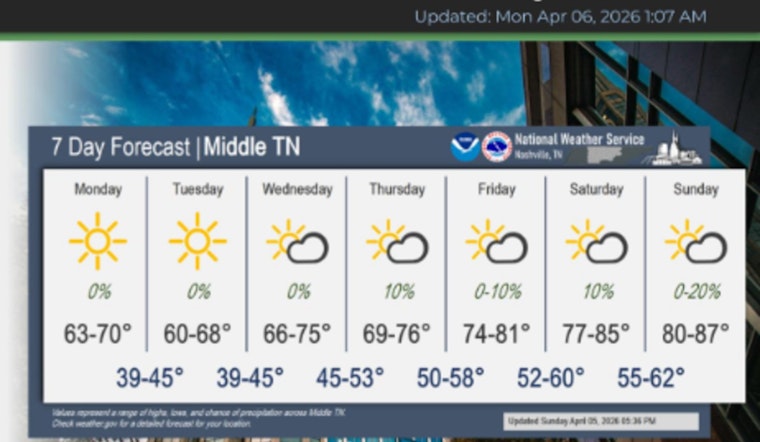
The National Weather Service Nashville is calling for mostly sunny skies with a high near 71°F and north-northwest winds around 0–5 mph. Measurable rain is not expected through Tuesday, so outdoor plans should be in good shape.
Tonight looks mostly clear, with lows dropping into the mid-40s. Early risers will still feel that nip in the air Tuesday morning, even as afternoons continue to warm.
Warming Through The Week
Temperatures step up a notch as the week goes on: highs reach the mid-70s on Wednesday, April 8, then climb into the upper 70s and low 80s by Friday. By Saturday, April 11, and Sunday, April 12, highs are forecast to hit the mid-80s and flirt with near-record territory, a stretch of warmth we flagged earlier in our summerlike sizzle preview.
Dry Pattern, Drought Watch
A ridge of high pressure is expected to keep most of the meaningful moisture bottled up to the west, which means rain chances stay low for the next several days. That warm, quiet pattern could nudge short-term dryness a bit, especially for those keeping an eye on lawns, gardens, or outdoor events.
If you are planning anything outside, it is wise to assume little help from Mother Nature in the form of rainfall through next week.
What You Should Do
Layer up for the cool mornings, then be ready to shed the jacket and break out the sunglasses by midday. By the weekend, with readings headed into the 80s, make sure to hydrate if you are working or exercising outside.
Keep an eye on updates from the National Weather Service Nashville for any last-minute forecast tweaks, and check local city guidance in case watering restrictions or early-season heat advisories pop up.


