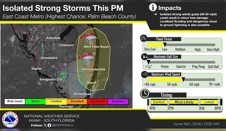
South Florida’s daily weather gamble is tilting a little stormier today, with the National Weather Service in Miami warning Tuesday morning that an isolated strong storm or two could track along the Atlantic coast between about 1 p.m. and 8 p.m. Forecasters say these hit-or-miss cells could bring heavy rain that triggers localized flooding, dangerous cloud-to-ground lightning, and isolated wind gusts of 40–55 mph strong enough to snap branches and topple small trees. City officials are urging people to keep a close eye on conditions and be ready to head indoors quickly if storms start to bubble up.
The alert, first posted by the National Weather Service's Miami office and then pushed across social media, was picked up and re-shared by the City of Hollywood on X around mid-day. The Hollywood repost amplifies the NWS advisory for neighborhoods lining the Broward and Miami-Dade coastlines.
RT @NWSMiami: 6/16 @ 11AM: An isolated strong storm or two is possible between 1-8 PM today along the east coast of South Florida.
— City of Hollywood, FL (@cohgov) June 16, 2026
What Forecasters Are Saying
Meteorologists at the National Weather Service in Miami are flagging the strongest storm cells as the ones to watch, noting they could deliver brief but intense downpours capable of causing localized street flooding along with dangerous lightning strikes. In its advisory, NWS Miami urges residents to monitor radar and move indoors at the very first sign of lightning rather than trying to “wait it out” outside.
Local Impacts And Park Sirens
Broward County’s park-goers may get a high-tech heads-up if storms roll in. The county operates an electronic lightning-prediction system in many parks, and officials say a long 15-second horn blast means drop the picnic, take shelter immediately, and stay put until the all-clear sounds before resuming activities. Broward County also reminds residents and visitors to stick to the 30/30 rule: if the time between seeing a lightning flash and hearing thunder is under 30 seconds, move indoors and remain sheltered for 30 minutes after the last rumble.
How To Stay Safe This Afternoon
Officials recommend riding out any storms inside a sturdy building or enclosed vehicle, securing loose outdoor items ahead of time, and steering clear of flooded streets and intersections. If you hit standing water on the road, remember the familiar warning: “turn around, don’t drown.” The National Weather Service’s Turn Around, Don't Drown campaign offers more guidance on flood-related driving and water hazards, and residents are encouraged to keep tabs on local alerts and radar using trusted weather apps or NOAA Weather Radio as storms threaten.


