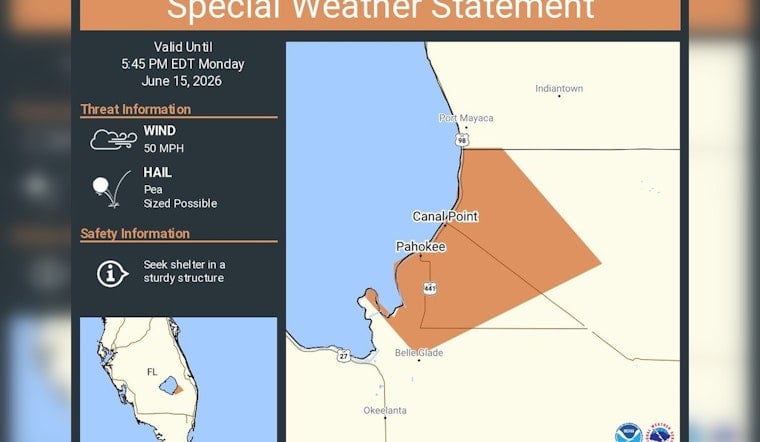
A fast-hitting burst of rough weather rolled across the Lake Okeechobee corridor Monday afternoon, prompting the National Weather Service in Miami to issue a special weather statement for Pahokee and Canal Point through 5:45 p.m. EDT. Forecasters flagged radar-indicated storm cores capable of producing pea-sized hail and wind gusts near 50 mph, urging residents in the Glades communities to get inside sturdy structures as the line of storms moved through.
The notice, posted on NWS Miami's social feed just after 5 p.m. EDT, specifically called out Port Mayaca, Indiantown, Canal Point, Pahokee and Belle Glade as being in the path. According to NWS Miami, the advisory was valid until 5:45 p.m. EDT and advised people to "seek shelter in a sturdy structure." Officials stressed that these are short-fuse advisories tied to radar-indicated storm cores, which can strengthen, weaken or shift quickly.
Radar Shows Fast, Punchy Storm Cores
Regional alert products and local severe-weather summaries repeatedly note that these quick-hitting cells can pack a brief punch, with intense gusts and small hail the main threats. Weather Underground's local alert page for Pahokee highlights previous NWS special weather statements for the Glades that list pea-size hail and gusts up to about 50 mph as the primary hazards. That kind of wind can snap small limbs, send unsecured patio furniture flying and trigger momentary power blips.
What Officials Are Warning
National Weather Service products for South Florida continue to hammer home the same points: radar-indicated 45 to 50 mph gusts and pea-size hail are on the table, and people should stay in a safe building until the storm passes. The NWS language notes that gusty storm cores can move quickly and produce localized damage, especially in low-lying and lakeside communities around Lake Okeechobee. Residents are urged to keep NOAA Weather Radio, local broadcast outlets and the NWS Miami feed close at hand in case the situation escalates into a formal warning.
How Locals and Boaters Should Respond
Officials recommend heading indoors to a sturdy structure, staying away from windows and steering clear of flooded streets while storms move through. Boaters and anglers on Lake Okeechobee have been urged in recent alerts to seek safe harbor immediately when thunder is in the area, a recurring point in local coverage of the lake's quick-forming squalls. For the latest statements and on-the-water guidance, officials point to National Weather Service products and local alerts, and emphasize that short-fuse advisories should be taken seriously until they expire.


