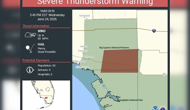
A fast-building severe thunderstorm warning lit up parts of Collier County on Wednesday afternoon, putting isolated Everglades communities and sprawling parklands on edge as forecasters flagged the potential for damaging winds and small hail. Radar indicated the strongest cells could pack wind gusts up to 60 mph with hail roughly the size of a penny, and the warning was set to stay in place through 3:45 p.m. EDT. The storm line pushed across mostly unpopulated stretches of Big Cypress and Everglades National Park, but it also moved over major cross-state routes, including I-75 and U.S. 41.
Official Warning and Hazards
The National Weather Service detailed the severe thunderstorm warning in its formal bulletin, highlighting the risk of wind gusts up to 60 mph along with penny-size hail and placing portions of western Collier County under the alert. Forecasters cautioned that the gusty winds could snap tree limbs and make driving treacherous for anyone caught on the road, according to the National Weather Service.
Where the Threat Was Focused
In a post on X, NWS Miami honed in on a handful of vulnerable spots, specifically naming Chokoloskee, Sunniland and Ochopee, and including both Everglades National Park and Big Cypress National Preserve inside the warning polygon. The office also flagged I-75 and U.S. 41 as travel corridors that could see sudden hazardous conditions under the passing storms, according to NWS Miami.
How to Stay Safe
Local officials urged anyone within the warning area to ride out the weather in a sturdy building, hold off on travel until the worst of the storm moves through and secure any loose outdoor items that might turn into airborne projectiles in high winds. Collier County Emergency Management maintains local alert systems and preparedness tips for residents and visitors navigating severe weather, according to Collier County Emergency Management.


