

























































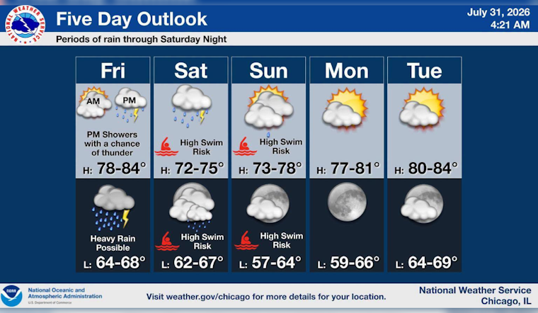
Chicago starts Friday, July 31, under mostly cloudy skies with temperatures in the 70s, but the dry window will not last. Rain showers are likely after 2 p.m., with a high near 83 before temperatures slide into the upper 70s during the afternoon.
Rain Builds Friday Night
Showers should become more widespread Friday evening before thunderstorms develop overnight. The chance of rain rises to 100%, with three-quarters to 1 inch possible and southeast winds around 15 mph gusting up to 25 mph.
The broader storm system could bring 1 to 3 inches of rain across the area, with locally higher totals, according to the National Weather Service Chicago. That could make Friday night and Saturday a messy stretch for driving, outdoor events and anyone hoping to keep their weekend plans outdoors.
Saturday Looks Wet And Blustery
Saturday will stay cloudy, with showers and thunderstorms, a high near 73 and another three-quarters to 1 inch of rain possible. East-northeast winds of 15 to 20 mph could gust as high as 35 mph, while temperatures fall toward the lower 70s during the afternoon.
Lakefront Conditions Turn Dangerous
A Beach Hazards Statement is in effect from late Friday night through Monday morning for southern Lake Michigan beaches, including Lake, northern Cook and central Cook counties. Waves of 6 to 9 feet and dangerous currents are expected, making swimming potentially life-threatening; beachgoers should stay out of the water and avoid piers, jetties, breakwalls and other shoreline structures.
Clearer Weather Returns Sunday
Sunday brings partly sunny skies, a high near 72 and continued northeast gusts up to 30 mph, followed by a mostly clear night near 63. Monday looks sunny and calmer at 76, with another sunny 80-degree day expected Tuesday before slight shower and thunderstorm chances return Wednesday and Thursday.



