

























































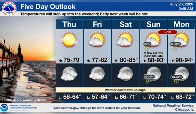
Chicago woke up to the kind of morning tourism brochures dream about: mostly clear skies, crisp air in the mid to upper 50s at area stations, and plenty of early sun. That bright sunshine will stick around today, with highs near 76°F and a light south‑southwest breeze around 5 to 10 mph. A weak lake breeze is expected to drift inland this afternoon, but most neighborhoods should stay comfortably mild.
Today
The afternoon stays solidly sunny, with temperatures peaking in the mid‑70s and only a light wind to contend with. Clouds creep in tonight, turning skies mostly cloudy as readings drop to around 66°F. Winds ease and shift to the south‑southeast overnight. Rain holds off, with no precipitation expected through Friday morning.
Weekend Outlook
Friday and Saturday keep things pleasant and seasonable, with highs in the upper 70s to low 80s before the real warmth muscles in. Heat starts building Sunday into Monday, with forecast highs climbing into the upper 80s on Sunday and near the low 90s on Monday, along with increasing humidity. Forecasters say heat headlines could be needed, and multiple rounds of severe storms with damaging winds and flash flooding are possible across the Great Lakes Sunday and Monday, according to National Weather Service Chicago.
Be Prepared
There are no watches or warnings posted this morning, but late‑week changes could bring both heat and storm impacts to the area. If the heat ramps up as expected, the city operates cooling centers and uses libraries as cooling sites. Residents can call 311 or check the City of Chicago cooling center map for locations and hours. Stay hydrated, ease up on strenuous outdoor plans during the hottest part of the day, and keep an eye on hourly forecast updates.
Bottom line: today is prime time for outdoor plans. Enjoy the sunshine while it behaves itself, and give the forecast another look before locking in any big weekend events.





