

























































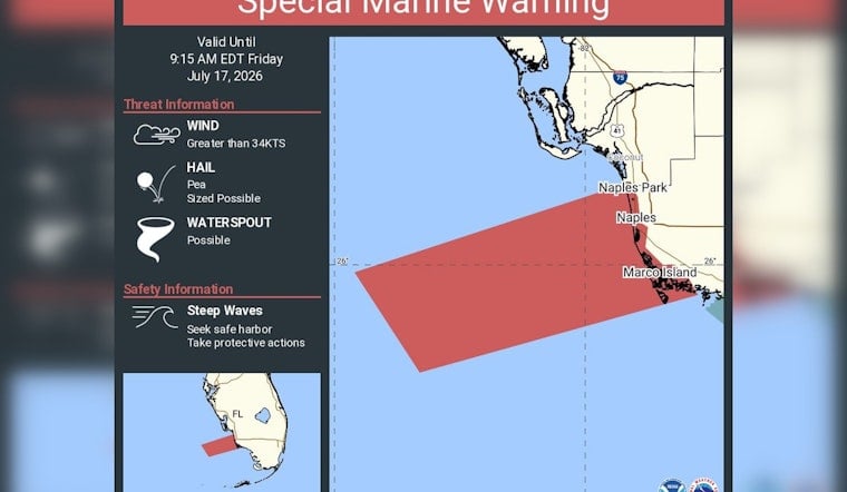
The National Weather Service in Miami threw a bright yellow flag over the Gulf on Friday, July 17, 2026, issuing a Special Marine Warning for waters from Chokoloskee to Bonita Beach. The alert covered both the offshore stretch about 20 to 60 nautical miles out and the near‑shore coastal waters out to 20 nautical miles, warning of sudden squalls capable of whipping up steep, choppy seas, wind gusts above 34 knots, pea‑sized hail and brief waterspouts strong enough to overturn small craft. The warning was set to run into the morning, and boaters were urged to head for safe harbor without delay.
According to NWS Miami, the Special Marine Warning explicitly covered both the offshore sector (GMZ676) and the coastal sector (GMZ656), with an expiration time of 9:15 a.m. EDT on July 17. The NWS marine zone pages show those sectors extending past Marco Island, Golden Gate and Naples, and forecasters told mariners to seek safe harbor and secure vessels as conditions worsened. NWS Marine Forecasts carry the daily and near‑term updates for those zones.
Special Marine Warning including the Waters from Chokoloskee to Bonita Beach FL from 20 to 60 NM and coastal waters from Chokoloskee to Bonita Beach FL out 20 NM until 9:15 AM EDT
— NWS Miami (@NWSMiami) July 17, 2026
What mariners should watch for
These short‑fused squalls that trigger Special Marine Warnings can go from distant rumble to dangerous within minutes, bringing wind gusts well above 34 knots, frequent lightning, sudden steep waves and small hail. According to the NOAA Marine Fact Sheet, waterspouts and hail can form quickly in subtropical coastal waters and can overturn or disable small vessels. Boaters are urged to treat radar‑indicated thunderstorm advisories as immediate threats and to suspend open‑deck operations until the storms pass.
Where this warning applies
The warning corridor hugs the Collier County Gulf coast from Chokoloskee up toward Bonita Beach and then stretches offshore toward the deeper Gulf, putting Marco Island, Naples and nearby fisheries squarely in the zone of greatest immediate concern. Local reports and forecast products flag Naples Park, North Naples and Bonita Shores among the nearshore communities that could see abrupt swings in wind and seas during the episode. For zone maps and official details, see the NWS GMZ676 marine forecast and local coverage on Everglades boaters on high alert.
Why these storms come up so fast in summer
Sea‑breeze collisions over the shallow Gulf shelf, combined with high summer moisture, make the GMZ656/676 corridor vulnerable to compact, high‑intensity thunderstorm cells that can spin up quickly. NOAA marine guidance notes that these fast‑forming cells often give recreational boaters and small‑craft operators very little lead time. That rapid evolution is exactly why forecasters issue short‑notice Special Marine Warnings instead of longer advisories when radar or observer reports point to imminent, localized severe marine conditions.
How to stay safe and get updates
If you are already on the water, the advice is simple and urgent: head for the nearest safe harbor, secure any loose gear and, if possible, stay below decks until the warning period ends. Keep a VHF radio tuned and monitor NOAA Weather Radio for the latest updates; the U.S. Coast Guard Navigation Center recommends using VHF channel 16 for primary short‑range communication and notes that storm warnings are broadcast on NOAA Weather Radio. Before heading back offshore, check your local forecast office's marine products, and report any hazardous conditions to the Coast Guard or the NWS when it can be done safely.



