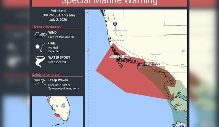
Sudden, punchy storms had the National Weather Service in Miami sounding the alarm Thursday for Gulf-side coastal waters from East Cape Sable to Chokoloskee and from Chokoloskee to Bonita Beach, out to 20 nautical miles. A Special Marine Warning was issued for the area, alerting mariners to dangerous, fast-developing gusts and possible waterspouts, and was set to remain in effect through 6:00 p.m. EDT.
Special Marine Warning including the Coastal waters from East Cape Sable to Chokoloskee FL out 20 NM and Coastal waters from Chokoloskee to Bonita Beach FL out 20 NM until 6:00 PM EDT
— NWS Miami (@NWSMiami) July 2, 2026
What the warning covers
According to NWS Miami, the Special Marine Warning covers the coastal waters from East Cape Sable to Chokoloskee and from Chokoloskee to Bonita Beach, extending 20 nautical miles offshore. Forecasters told mariners to “seek safe harbor and take protective actions” while the threat remained in place, highlighting wind gusts over 34 knots and the chance of waterspouts during the brief but intense episode. Small-craft operators and charter captains were urged not to wait around and to move quickly to safety.
Which marine zones are affected
The advisory targets marine zones GMZ657 and GMZ656, which include Gulf waters off Marco Island, Golden Gate, Naples and portions of the Everglades, according to NOAA. These nearshore stretches are notorious in summer for pop-up afternoon squalls that can flip calm seas into steep, choppy waves in a hurry. Boaters working Collier County waters are being told to treat conditions as hazardous until the warning officially expires.
Recent local squalls underscore the risk
A recent burst of weather that had Everglades boaters racing for cover triggered a similar short-fuse marine warning and sent dozens of smaller vessels darting into protected coves. That episode showed just how little notice mariners sometimes get in these zones. Local captains say those compact storm cells can appear quickly and leave unprepared boats exposed, which is why summer afternoons have become especially dicey for anyone planning offshore trips this week.
Why mariners should take this seriously
Special Marine Warnings are reserved for situations when short-lived storms can generate wind gusts of 34 knots (39 mph) or more, or when waterspouts are seen or expected, hazards that can, the NWS notes, “easily overturn boats,” according to NWS. These events can also bring a quick jump in wave height, frequent lightning and sharply reduced visibility, a combination that is especially dangerous for small vessels. That cocktail of threats is why the Miami office is telling anyone on the water to head for shelter without delay.
How to stay safe
If you are already offshore, the guidance is straightforward: run for safe harbor as soon as possible, secure loose gear and steer clear of bridges and shoals where waves can stack up. Keep VHF radios and NOAA Weather Radio on, follow updates from the Miami forecast office and hold off on departures until the warning is lifted. Local marinas and charter operators typically flag these advisories on their own channels when conditions turn hostile.
This story will be updated if the Miami office extends or expands the warning. For now, officials say mariners should treat the affected waters as hazardous through the posted expiration time and proceed with extra caution.


