

























































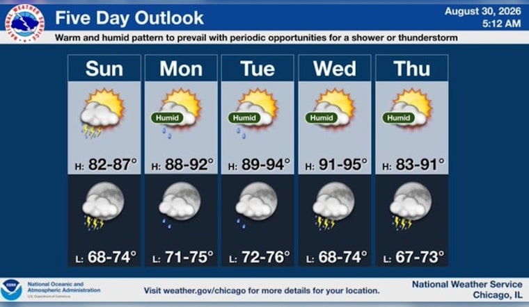
Chicago is waking up to partly cloudy skies and temperatures in the low 70s Sunday, but the calm opening may not last. Showers and thunderstorms are possible through the morning and again in spots during the afternoon, with a high near 84 and south-southwest winds gusting up to 25 mph.
The rain chances are highest from early morning into around lunchtime, when the forecast calls for a 50% chance of precipitation and brief downpours. The latest outlook is a sharper turn from Hoodline’s Saturday forecast, adding more storm potential Sunday while pushing the hottest stretch of the week higher.
Storm Chances Ease As Heat Builds
Storm chances drop this evening, with only a slight chance of showers or thunderstorms before 8 p.m. Sunday night will stay mostly cloudy and mild, with a low around 74 and southwest winds near 10 mph.
Monday brings a warmer and more humid setup, with a slight chance of early storms before partly sunny skies and a high near 89. Tuesday could reach 92, followed by a mostly sunny Wednesday with a high near 93, according to the National Weather Service Chicago/Romeoville.
A Hotter Midweek, Then A Cooler Turn
The National Weather Service says heat indices could rise into the mid-to-upper 90s by midweek, with some parts of the broader forecast area potentially exceeding 100 degrees. No heat watch, warning or advisory is currently posted, but the combination of high temperatures and humidity will make outdoor plans feel more strenuous.
Storm chances return periodically Wednesday night through Saturday, while temperatures ease back into the mid-80s Thursday and Friday and near 83 Saturday. For Sunday, the practical game plan is simple: keep an eye on the sky early, allow for a few dry breaks, and save the sunglasses for the gaps between showers.





