

























































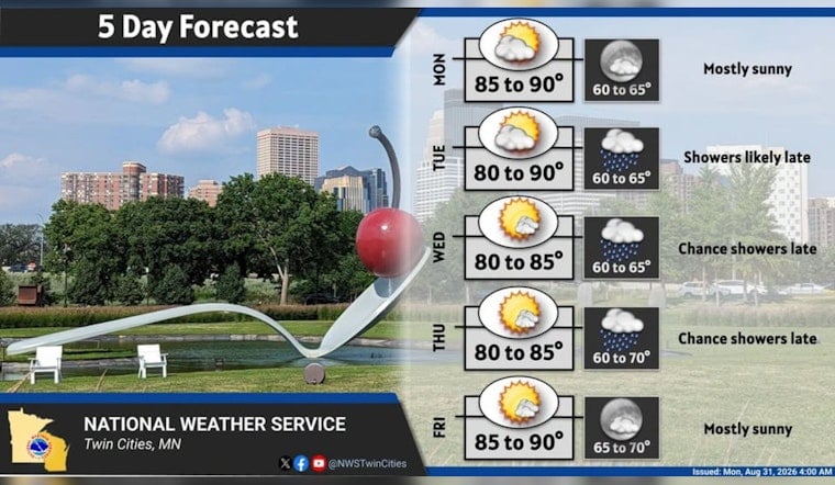
Minneapolis is waking up clear and near 72 degrees Monday, but the city is headed for another hot, sticky afternoon with a high around 89. Humidity will ease as a front crosses the area near midday, and skies should turn partly to mostly sunny by afternoon. Rain is essentially a non-issue today.
The National Weather Service Twin Cities/Chanhassen says winds will shift from light southerly to west and northwest at 5 to 10 mph as the front moves through. Patchy fog in parts of western and central Minnesota should lift after sunrise, while around Minneapolis-St. Paul International Airport, fog is expected to stay mostly in nearby low spots rather than disrupt the terminal. No watches, warnings or advisories are posted.
Tuesday Stays Hot Before Showers Arrive
Tuesday will look a lot like Monday, with partly sunny skies, light west-southwest winds and another high near 89. The forecast turns wetter after 7 p.m., when rain showers become likely with a 60% chance of precipitation. The latest timing is a notable update from the earlier Hoodline forecast, which had a less defined rain window.
Early Wednesday Rain Gives Way To Sunshine
Showers are likely before 7 a.m. Wednesday, with new rainfall generally expected to stay below a tenth of an inch. After that, clouds should break and temperatures will climb to about 84 degrees under mostly sunny skies. The rest of the week remains warm, though rain chances become more occasional than widespread.
Warm Weather Lingers Into The Weekend
Thursday could bring a few early showers or thunderstorms before mostly sunny skies take over, with a high near 85. Friday should reach about 88 with only a slight chance of a morning shower or storm, while Saturday looks mostly sunny and similarly warm. Sunday brings another chance for rain showers and a high near 85.
The mostly dry stretch comes as the region continues to run short on rainfall. The weather service says its forecast area is 3.76 inches below normal for August and 6.83 inches below normal for the year; without additional rain Monday, August would rank as the fourth-driest on record at 0.46 inches.




