

























































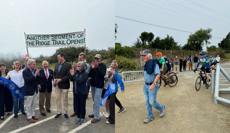
A stretch of San Mateo County watershed land that had been off-limits to unguided hikers for nearly a century opened to the public on Monday, when the San Francisco Public Utilities Commission unveiled the six-mile Skyline Watershed Ridge Trail near Redwood City. Bob Siegel, who has sat on the board of the Bay Area Ridge Trail Council, was among the first hikers on the new path. “How could I possibly not come here?” Siegel said he had been anticipating the trial for about a quarter of a century, as per The Press Democrat.
The new segment runs parallel to Skyline Boulevard south of highways 35 and 92 and extends to the boundary of the Phleger Estate, according to The Press Democrat. Its opening pushes the broader Bay Area Ridge Trail network to 413 completed miles toward a planned 550-mile continuous loop circling all nine Bay Area counties, according to the San Francisco Public Utilities Commission. Janet McBride, executive director of the Bay Area Ridge Trail, said the new mileage brings the regional loop to nearly three-quarters complete.
The project was funded jointly by the SFPUC and a Federal Highway Administration grant, carrying a $25 million price tag and beginning construction in 2024, per the Press Democrat's reporting. San Mateo County District 3 Supervisor Ray Muller, whose district includes cities from Pacifica to San Mateo along with the unincorporated areas the trail crosses, called the project a lasting community asset.
A Century of Locked Gates Around a Vital Watershed
The SFPUC owns the 23,000-acre Peninsula Watershed, land that has stored drinking water for 2.7 million Bay Area residents while remaining closed to unguided public access for nearly a century, according to the Bay Area Ridge Trail Council. The reservoirs on this land, including Pilarcitos Lake, Crystal Springs, and San Andreas, function as local storage for the Hetch Hetchy Regional Water System, which carries Sierra Nevada runoff more than 160 miles to Bay Area taps, the utility notes.
Before this opening, the primary route through watershed land was the 10-mile Fifield-Cahill Ridge Trail, which the SFPUC opened in 2003 but which allows only guided, docent-led outings. That older trail extends from Skyline Quarry at Highway 92 to the watershed's northern boundary, and the new Skyline Watershed Ridge Trail's flat, half-mile ADA-compliant segment feeds directly into it, per the Press Democrat.
The land's ecological stakes are high. The Peninsula Watershed holds the highest concentration of rare, threatened, and endangered species anywhere in the nine-county Bay Area, serving as habitat for the San Francisco garter snake, California red-legged frog, and Mission blue butterfly, according to the Sierra Club. San Francisco Public Utilities Commission member Joshua Arce said the agency must balance watershed protection with recreational opportunities as more of the land opens to visitors.
Rules of the Trail: Permits, No Dogs, No E-Bikes
Access comes with conditions. Trail regulations bar electric bicycles, motorized vehicles, and dogs other than service animals, and require hikers, cyclists, and equestrians to use cleaning stations for shoes, bike tires, and horse hooves to prevent the spread of invasive plants and pathogens, according to SFPUC permit documents. Visitors must obtain a free permit, available on the SFPUC website, and the trail is open daily from 6 a.m. to 6 p.m.
The new trailhead staging area sits on Highway 35 south of Highway 92 and includes a new parking lot with 22 standard spaces, five trailer spaces, and two ADA spaces. There is no drinking water available along the 12-mile round-trip route, though two restrooms are positioned near mile markers 2 and 5, so visitors need to pack their own water. Construction also added safety infrastructure along Highway 35, including Knox-box key safes for emergency fire department access, bollards, and vehicle-deterrent fencing to manage the remote, forested corridor.
Gaps Remain North and South of the New Segment
The newly opened stretch does not yet connect directly to neighboring trail networks. Closing the northern gap across Highway 92 to Skylawn Memorial Park and the southern gap across Skyline Boulevard to Purisima Creek Redwoods still requires future planning and funding, according to the Bay Area Ridge Trail Council. The Bay Area Ridge Trail Council marked the opening with a private ceremony.
On the southern side of that gap, the Midpeninsula Regional Open Space District has a long-term plan for its adjacent Purisima Creek Redwoods Open Space Preserve that includes expanding the North Ridge parking lot to link with the Bay Area Ridge Trail and building a new “Purisima-to-the-Sea” trail, according to the Midpeninsula Regional Open Space District. Midpen manages more than 4,700 acres adjacent to the watershed lands, positioning it as a key partner in eventually stitching the ridgeline route down to the Pacific Coast.
A 37-Year Build Toward a National Trail
The Bay Area Ridge Trail traces its roots to 1987, when William Penn Mott Jr., then President Ronald Reagan's national parks director, helped organize the effort and provided advice and funding to get it started. The trail's first mile was dedicated in 1989 at Purisima Creek Redwoods Preserve and Huddart County Park in San Mateo County. From there, the network reached 100 miles within its first year, hit 200 miles five years later, and climbed to 300 miles by 2006, according to the Press Democrat's account of the trail's history. In May, the network welcomed a 14.1-mile section along San Jose's southern edges.
That momentum has attracted federal attention. U.S. Representative Jared Huffman and Senator Adam Schiff introduced legislation in January directing the National Park Service to study designating the full 550-mile Bay Area Ridge Trail as a National Scenic Trail, a status currently held by only 11 long-distance routes nationwide, including the Pacific Crest Trail, according to the Bay Area Ridge Trail advocacy group. Hoodline previously reported on that federal push when the bill was introduced.
For now, the Skyline Watershed Ridge Trail stands as the latest concrete step in that decades-long build-out, opening land that had been locked away since long before most of today's hikers were born. Siegel's quarter-century wait to walk it captures what the milestone means to the trail's longtime advocates, even as planners acknowledge the loop still needs its missing links across Highway 92 and Skyline Boulevard to become the seamless nine-county route organizers first imagined in 1989.





