

























































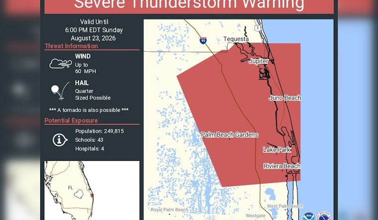
A Severe Thunderstorm Warning is in effect for a swath of northern Palm Beach County until 6 p.m. Sunday, with forecasters flagging winds up to 60 mph, hail potentially the size of a quarter, and a possible tornado embedded in the storm. The alert covers Tequesta, Jupiter, Juno Beach, Palm Beach Gardens, Lake Park, Riviera Beach, Royal Palm Beach, West Palm Beach, and Westgate.
According to NWS Miami, the warning exposes an estimated 249,815 people, along with 43 schools and four hospitals, to potential impacts. The National Weather Service defines a Severe Thunderstorm Warning as a storm capable of producing wind gusts of at least 58 mph or hail at least one inch in diameter, meaning Sunday's storm meets that threshold with room to spare on the wind side and sits right at the line on hail size.
Why a Tornado Threat Didn't Trigger a Phone Alert
The inclusion of a tornado threat alongside the wind and hail warning might raise eyebrows for residents who didn't get a blaring phone alert, but that's by design. Under National Weather Service procedures, forecasters attach a “Tornado Possible” tag to a Severe Thunderstorm Warning when radar indicates low-level rotation or environmental conditions favor brief tornadic development, even though that tag doesn't trigger an automatic Wireless Emergency Alert on smartphones. Since a 2021 update to its warning system, NWS reserves those automated mobile alerts for “destructive” category storms with winds exceeding 80 mph or hail larger than 2.75 inches, meaning Sunday's storm — real as the risk is — falls short of that higher bar.
The setup fits a well-worn seasonal pattern. Historical weather data compiled by TornadoArchive and NOAA shows August is historically the peak month for tornado occurrences in Palm Beach County, accounting for 31 of the 199 total confirmed tornadoes recorded in the county between 1680 and 2025. The Florida Climate Center attributes the timing to strong surface heat colliding with sea breezes moving inland from the Atlantic and the Gulf, a mechanism that routinely produces the kind of intense localized updrafts capable of spinning up brief, short-lived tornadoes along squall lines and sea-breeze boundaries.
Four Hospitals and Dozens of Schools Sit Inside the Warning Zone
Among the facilities inside the warning polygon are major medical centers serving northern Palm Beach County, including Jupiter Medical Center, Palm Beach Gardens Medical Center, and St. Mary's Medical Center in West Palm Beach, according to the Palm Beach County Medical Society. The 43 schools caught in the exposure zone are part of a district that builds beyond baseline Florida Building Code requirements, incorporating ICC 500 storm shelter standards across its campuses, per Facilitiesnet — construction that lets many of those same buildings double as community shelters during severe weather.
Power reliability is also a concern anytime gusts reach 60 mph, since falling tree limbs and flying debris are the leading cause of localized electrical outages during summer squalls. Florida Power & Light officials have noted that comprehensive damage assessments typically take up to 24 hours before the utility can offer accurate restoration timelines to affected customers, according to First Coast News.
Lightning and Rainfall Add to the Risk
Wind and hail aren't the only hazards riding along with Sunday's storm. The Palm Beach County Office of Emergency Management notes that Florida experiences more lightning strikes and lightning fatalities than any other state in the nation, with Central and South Florida averaging 80 to 90 thunderstorm days a year — making lightning the top weather-related killer in the state even when wind and hail grab the headlines.
The storm also arrives during what climatological records describe as the hottest and wettest stretch of the year in Palm Beach County; August typically brings 17 rainy days and more than 9 inches of monthly rainfall, according to Travelscoop. That heat and moisture combination is exactly the fuel that produces rapid, short-fuse storm development across South Florida through late summer.
Sunday's warning continues a run of short-notice severe weather alerts that have hit Palm Beach County repeatedly this summer. Hoodline reported on a late-night squall line that triggered a similar warning across the county in July, bringing damaging gusts and small hail — part of a broader pattern of frequent short-fuse thunderstorm advisories that has defined the region's 2026 summer season.



