

























































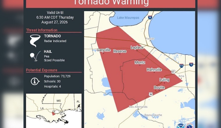
A tornado warning tore through the pre-dawn hours over St. Charles Parish and neighboring communities Thursday, prompting the National Weather Service to flag a radar-indicated twister capable of putting more than 73,000 people in its path before the alert expired at 6:30 a.m. Pea-sized hail was also considered possible as the storm pushed across the region. The warning stretched across a wide swath of the River Parishes, from LaPlace and Reserve to Luling, Boutte, Hahnville and Des Allemands, before lifting at its scheduled expiration.
The alert, posted by St. Charles Parish on Facebook, listed the threat as originating from the National Weather Service and credited the warning to the agency's New Orleans forecast office, tracked online as NWSNewOrleans. Communities named in the warning included Garyville, Montz, Ama, Bayou Gauche, Raceland and the Lake Maurepas area, alongside the more populous hubs of LaPlace and Hahnville. Parish officials urged residents to stay weather-aware and use caution as the storms moved through, according to the post.
What Radar Indicated Actually Means
The warning carried a “Radar Indicated” tag rather than “Observed,” a distinction that matters for understanding how seriously to take an alert like this one. As WZZM13 explains, a radar-indicated designation means Doppler radar detected strong mesocyclone rotation inside the storm, but no spotter or official had visually confirmed a tornado on the ground. That distinction is built into the National Weather Service's Impact-Based Warning framework, which tags every tornado warning by both source — Radar Indicated or Observed — and threat severity, such as Considerable or Catastrophic, a system created to sharpen public risk communication.
Meteorological estimates cited by the same station suggest that only about 20% to 30% of supercell thunderstorms showing strong radar rotation actually produce a tornado that touches down, since mid-level atmospheric rotation frequently fails to consolidate at ground level. That statistic helps explain why forecasters issue warnings well before confirming an actual twister — the goal is to give residents time to shelter before a vortex potentially forms, not after. It remains unknown from available reporting whether Thursday's radar-indicated rotation ever produced a confirmed touchdown or caused damage in any of the warned communities.
How Forecasters Calculated the Population at Risk
The warning estimated potential exposure at 73,729 people, along with 30 schools and 4 hospitals inside the threat area. The National Weather Service generates those figures by overlaying GIS storm-threat polygons onto federal census and facility databases, allowing forecasters to produce real-time estimates of who and what lies in a storm's path as it moves. That kind of exposure modeling is part of why warnings for rural-feeling stretches of the River Parishes can still carry numbers rivaling a mid-sized city.
A Region With a Violent Storm History
Thursday's warning landed in a parish with recent, painful experience with tornadoes. In December 2022, an EF-2 tornado packing estimated 120 mph winds struck St. Charles Parish communities including Killona and Montz, damaging more than 50 structures, injuring eight people and killing one, according to data from the NOAA National Centers for Environmental Information. That storm was part of a larger severe weather outbreak across Southeast Louisiana. St. Charles Parish also relies on a network of outdoor tornado sirens, which emergency management officials activate during active warnings to push residents outdoors toward interior shelter, as reported by WWL-TV.
LaPlace itself carries an even longer history of destructive tornadoes. An F4 twister struck the town in December 1983, destroying 30 homes and injuring 25 people, and an F3 tornado during Hurricane Andrew in August 1992 killed two people there, according to the National Weather Service. Those historical benchmarks help explain why local officials treat radar-indicated rotation with urgency even before a tornado is confirmed on the ground.
Signing Up for Alerts
St. Charles Parish operates an opt-in emergency messaging network called SCP Alerts through its Emergency Operations Center, letting residents receive localized weather and emergency notifications by texting SCPALERTS to 888777 or registering at scpemergencyalerts.com. Residents in neighboring St. John the Baptist Parish, which includes the warned towns of LaPlace and Reserve, can sign up for similar localized broadcasts by texting SJPWEATHER to 888777, according to L'Observateur. The two systems reflect how River Parishes agencies coordinate messaging across shared parish boundaries during fast-moving severe weather.
Thursday's early-morning scare also fits a broader seasonal pattern for the region. The National Weather Service's New Orleans/Baton Rouge forecast office notes that Southeast Louisiana sees a secondary peak in severe weather and tornado potential during late summer and fall, often driven by tropical moisture colliding with cold fronts. That pattern means River Parishes residents face tornado risk well outside the traditional spring season, a reality Hoodline has tracked in nearby St. John Parish and across the broader New Orleans area in recent months.





