

























































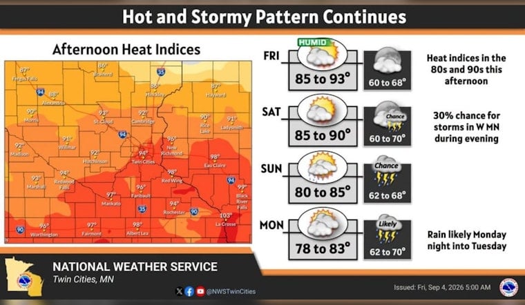
A Severe Thunderstorm Warning swept over downtown Minneapolis, Near North, Northeast, Golden Valley, St. Louis Park, and St. Anthony on Thursday afternoon, with the National Weather Service flagging 50 mph winds and quarter-sized hail as the main risks. The warning was set to remain in effect until around 3 p.m., but by evening the bigger threat had clearly moved elsewhere: northwestern Minnesota, where forecasters warned of large hail, damaging winds, and tornadoes.
The shift traces back to a Thursday afternoon call from NOAA's Storm Prediction Center, which downgraded the severe weather risk for the Twin Cities metro from a Level 2 Slight Risk down to a Level 1 Marginal Risk, according to Bring Me The News. At the same time, the agency kept a Level 2 Slight Risk in place across central and northern Minnesota, where atmospheric conditions were far more favorable for organized severe storms. Meteorologist Sven Sundgaard said the atmosphere would simply be too warm aloft for widespread storms to fire across southern Minnesota, a point echoed in the outlet's reporting that widespread storms were considered less likely across the majority of the Twin Cities.
Why Southern Minnesota Stayed Mostly Quiet
The technical explanation comes down to what forecasters call a cap. In a Wednesday Area Forecast Discussion, the National Weather Service's Twin Cities office noted mid-level atmospheric temperatures near 12°C at 700 millibars were creating a thermal lid over southern Minnesota, suppressing widespread storm initiation unless morning cloud cover cleared enough to let strong ground heating break through it. That thermodynamic ceiling helps explain why the Twin Cities saw only a brief, contained warning rather than the widespread severe weather some computer models had suggested.
Those models told two different stories heading into Thursday. The NAM model showed a bow echo crossing northern and central Minnesota later in the day, while the RRFS model pointed to explosive storm development over northern Minnesota during the afternoon. The National Weather Service describes a bow echo as a bow-shaped radar signature produced by a squall line or linear convective system, one that concentrates damaging straight-line downburst winds along its leading edge and can spin up localized tornadoes on its northern end. Forecasters cautioned that weather models had an inadequate understanding of how storms were behaving over eastern North Dakota, adding uncertainty to exactly how the system would evolve as it crossed into Minnesota.
Tornado Watch Stretches Across 17 Counties
The National Weather Service issued Severe Thunderstorm Watch 537 for northwestern Minnesota, covering 17 central and northwestern counties including Beltrami, Becker, Polk, Marshall, and Lake of the Woods. Forecasts within that watch warned of hail up to 1.5 inches in diameter, wind gusts as high as 70 mph, and isolated tornadoes. Bring Me The News reported that severe storms could produce hailstones up to 2 inches in diameter and isolated wind gusts up to 75 mph, with the tornado threat greatest in northwestern Minnesota.
Severe storms tracking east from areas west of Fargo were moving into northwestern Minnesota carrying threats of large hail, damaging winds, and tornadoes. Per the Storm Prediction Center, a cluster of storms was expected to continue eastward across northern Minnesota, with potentially repetitive severe storms shifting eastward and southeastward through early evening. Northwestern and north-central Minnesota were described as primed for significant storms, while additional storms were expected to develop along the trailing gust front as the system pushed through.
A Pattern of Late-Summer Volatility
Thursday's split outcome fits a broader pattern this season. Minnesota's Department of Natural Resources State Climatology Office has tracked September as the state's third-fastest-warming month, with average temperatures climbing 5.8°F between 1970 and 2025 — a trend that has extended July-like heat and storm energy later into the year. Even so, late-summer severe weather and tornadoes remain comparatively rare in Minnesota; FOX 9 reports the state averages 46 tornadoes a year, with more than 85 percent of them occurring between May and August.
The volatility isn't new to Minnesota communities this summer. Governor Tim Walz authorized state emergency disaster assistance in August for six counties — Becker, Crow Wing, Fillmore, Houston, Mower, and Winona — to repair public infrastructure damaged by tornadoes, straight-line winds, and flash flooding between late June and early July, a story Hoodline previously covered here. That authorization included Becker County, where an EF-2 tornado struck near Detroit Lakes. Thursday's watch for northwestern Minnesota arrived as a reminder that the same corridor remains exposed to fast-developing severe weather even as the calendar turns toward fall.
For now, the Twin Cities appear to have avoided the worst of Thursday's system, with the downtown Minneapolis warning expiring by mid-afternoon and no further widespread severe weather expected for the metro. Northwestern Minnesota residents, however, were urged to stay alert through the evening as the watch remained active and storms continued tracking east from the Fargo area.




