

























































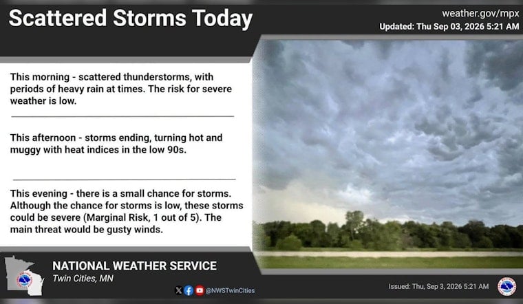
Minneapolis is starting Thursday clear and near 73 degrees, but the quiet opening may not last long. Showers and thunderstorms could move through this morning, with another round possible later as temperatures climb toward 87. The air is already humid, setting up a sticky day with a few possible weather plot twists.
Storm Risk Builds Thursday
Thursday carries a 60% chance of showers and thunderstorms, with the first round most likely during the morning and additional storms possible this afternoon and evening. Rainfall totals could reach between a tenth and a quarter of an inch, according to the National Weather Service Twin Cities.
The weather service says severe thunderstorms are possible this afternoon and evening, although no watches, warnings or advisories are posted for Minnesota or Wisconsin in the current forecast. Anyone with outdoor plans should keep a way to get indoors quickly when thunder develops, especially as the forecast timing remains somewhat uncertain.
The updated storm concern is a sharper turn from the quieter setup outlined in Wednesday's forecast. For commuters, event organizers and anyone trying to squeeze in patio time, the safest bet is to watch the sky rather than assume the morning rain will be the whole story.
Friday Brings Back The Heat
Friday should be mostly sunny and hotter, with a high near 89 degrees. Heat-index values could climb into the mid-to-upper 90s and potentially approach 100 around the Twin Cities, so shade, water and breaks from strenuous outdoor activity will matter.
Saturday remains mostly sunny with a high near 87, but storm chances return Saturday night. Sunday brings a high near 85 and a 40% chance of showers and thunderstorms, mainly before early afternoon.
Labor Day Weekend Ends On A Stormier Note
Labor Day is expected to be cooler, with a high near 80 and a 50% chance of showers and thunderstorms. The unsettled pattern continues Monday night and Tuesday, when storms are likely and south winds could gust as high as 25 mph Monday night.
By Wednesday, temperatures should ease back to a more comfortable 78 degrees under mostly sunny skies, with only a slight early shower chance. Until then, Minneapolis gets a little bit of everything: storms, sunshine, heat and a holiday weekend that refuses to commit to one forecast.




