The city of Chicago is headed for a stretch of notably warm weather, extending the feel of summer further toward the edge of autumn. As we delve into the heart of the week, the National Weather Service's forecast anticipates "sunny" skies with an agreeable high near 77 degrees and gentle breezes moving from the east-northeast throughout the morning hours. The forecast details a shift to "clear" conditions tonight, dipping to a comfortable low around 63 degrees.
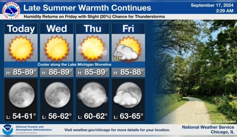
Late summer-like warmth will continue through the end of the week. Humidity levels will increase on Friday, as well as a return of low (20%) chances for a shower or thunderstorm. #ILwx #INwx pic.twitter.com/ScNDrrNNee
— NWS Chicago (@NWSChicago) September 17, 2024
The warmth will sustain itself as Wednesday heralds continued "sunny" skies and highs closely matching today's temperature, with light wind becoming east at 5 to 10 mph in the afternoon. As revealed in the detailed forecast, the weather remains mostly stable, but with a gradual uptick in humid conditions, specifically on Friday, along with "a 20 percent chance of showers and thunderstorms." These warmer temperatures and increased humidity levels are highlighted as late summer-like warmth continues.
Looking ahead, the Hazardous Weather Outlook released by the National Weather Service Chicago/Romeoville indicates a serene weather pattern for most days, but it draws attention to the weekend. Particularly on Saturday and Sunday, there’s a "limited thunderstorm risk" where residents should remain aware of the possibility of abrupt weather changes. While no immediate hazardous weather beckons, the outlook serves as a gentle reminder for the populace to remain vigilant.
Adding to the weekly climate synopsis, "Late summer-like warmth will continue through the end of the week. Humidity levels will increase on Friday, as well as a return of low (20%) chances for a shower or thunderstorm," as stated by the NWS Chicago.


