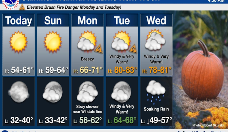
Residents in the Chicago area can look forward to a sunny weekend, but should prepare for a significant shift in weather conditions as the new week rolls in. According to the National Weather Service, Saturday's forecast predicts sunny skies with a high near 55, followed by increasing clouds in the evening and a low around 41. The tranquility of the weekend will give way to a warm and windy start to the week, with temperatures climbing to as high as 81 on Tuesday.
The mild conditions for today conceal the National Weather Service's caution, released in a Hazardous Weather Outlook, about the elevated risk of rapid brush and grass fire spread on Monday and Tuesday due to dry and windy conditions. Particularly on Tuesday afternoon, when winds could gust up to 40-45 mph, this concern becomes more pronounced. Small craft on the Illinois nearshore waters of Lake Michigan will face hazardous conditions due to strong southwesterly winds.
Next week’s brief warm spell will be cut short by a cold front expected to move in on Wednesday night, according to an X post from the National Weather Service Chicago. The front will bring showers, mainly after 10:00 p.m. on Wednesday, with a sharp temperature drop to a high near 59 on Thursday.
Mostly sunny skies will prevail this weekend before summer-like warmth returns (AGAIN) next week. The much above normal temperatures will be brief, however, as a cold front will sweep across the area Wednesday night. #ILwx #INwx pic.twitter.com/D3Hs8FWGmH
— NWS Chicago (@NWSChicago) October 26, 2024
Boaters should especially take heed during the midweek period; Tuesday and Wednesday could possibly present gale force winds, as outlined by the Hazardous Weather Outlook. The risk for small crafts continues through Thursday, with these conditions extending beyond the protective enclave of harbors and the nearshore to the broader expanse of Lake Michigan. The week concludes with more stable conditions, forecasting a mostly sunny Friday with a high near 57.


