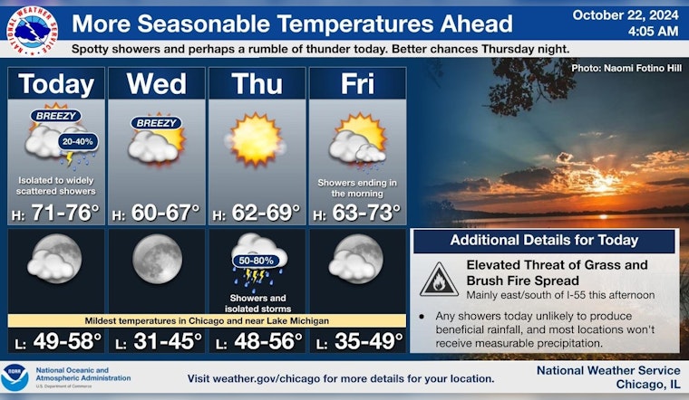
Chicagoans are facing a mixed bag of weather conditions this week, ranging from isolated showers to potential thunderstorms. According to the National Weather Service in Chicago/Romeoville, IL, there's a 20% chance of isolated showers today after 3 pm, with partly sunny skies and high temperatures nearing 73 degrees. Wind speeds are expected to pick up as well, gusting as high as 30 mph.
The city is also under an elevated fire weather risk, especially for areas located east of Interstate 55. The risk is driven by the forecasted gusty south winds that could reach up to 30 mph today, with occasional gusts potentially clocking in even higher at 35 mph. In a statement obtained by the weather forecast, the low afternoon humidity values might drop "as low as the upper 20s to around 30%," creating conditions conducive to grass and brush fire spread.
The clear skies are expected to prevail tonight with lows around 55, while Wednesday promises to become sunny after a partly cloudy morning. The temperatures might drop slightly compared to today, with a high expected around 62 degrees. It will remain breezy with northwest winds blowing 15 to 20 mph, gusting to as high as 30 mph. According to the Hazardous Weather Outlook, no spotter activation is deemed necessary through tonight.
Thursday maintains the trend with sunny weather and highs near 63. However, the serene conditions are soundly forecasted to be disrupted by night when showers and possibly a thunderstorm may develop after 1 am. The National Weather Service alerted in a post that "Better shower chances arrive Thursday night." The chance of precipitation on Thursday night is currently pegged at 80%, with a low of around 53 degrees leading into Friday morning.
[4:10 AM 10/22]: Isolated to widely scattered showers today, although these will not produce meaningful rainfall. Gusty winds and low afternoon humidities will drive an increased grass and brush fire spread threat E/S of I-55. Better shower chances arrive Thursday night. pic.twitter.com/G6wzZphWy8
— NWS Chicago (@NWSChicago) October 22, 2024
The activity on Lake Michigan is set to be choppy for much of the week, with hazardous conditions for small craft expected today, Wednesday, and possibly extending into Friday and Saturday, primarily for the Indiana nearshore, per the Hazardous Weather Outlook. Boaters should practice extra caution or avoid the water as conditions are likely to be rough. Beyond the tumultuous midweek forecasts, more tranquil weather will return by Sunday, with sunny skies and highs in the upper 50s anticipated to close out the weekend and kick-start next week.


