Chicago is preparing for a series of weather-related challenges this week, with a forecast that includes rain, thunderstorms, and impactful lake effect showers. The National Weather Service reported that today's weather in Chicago will likely feature showers and thunderstorms moving in after 2:00 p.m., accompanied by strong north northeast winds reaching up to 30 mph. An estimated 80% chance of precipitation promises significant moisture, with new rainfall potentially measuring between a quarter and half of an inch.
The situation continues into tonight as showers and a possible thunderstorm are expected before 7:00 p.m., followed by a partly cloudy sky and brisk breezes. Residents should anticipate a 60% chance of precipitation tonight, including the potential for thunderstorms that could bring higher amounts of rainfall. The National Weather Service outlines a Hazardous Weather Outlook that warns of "limited Thunderstorm Risk near the lake" and "Significant Frost/Freeze Risk" for the region tonight.
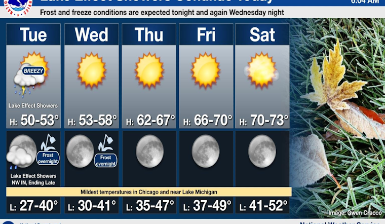
According to the forecast obtained from the National Weather Service, the city will experience a sudden shift toward sunny skies with high temperatures gradually climbing from 54 degrees on Wednesday to near 73 by Sunday. As Chicagoans move through the week, those brisk temperatures will give way to clearer and warmer days ahead.
Navigational warnings are also in place for Chicago's boaters and maritime community. The Weather Service has reported "hazardous conditions for small craft" along with a "Limited Thunderstorm Risk" and "Limited Waterspout Risk" on the waters of Lake Michigan. These conditions concern both the Illinois and Indiana nearshore waters and are expected to persist through Wednesday, according to the National Weather Service's lake advisory. Frost and freeze conditions are anticipated to continue through Thursday morning, signaling a stark transition from stormy to tranquil weather, which can create its own sets of challenges for the unprepared.
The NWS Chicago's latest X post reminds residents that lake effect showers and isolated storms are prevalent today, shifting mainly into northwest Indiana by this evening. Their message encapsulates the flux of the fall season in the Midwest - from the cold anticipation of frost to the promise of a warmer horizon.
Lake effect showers and isolated storms will continue today, shifting mainly into northwest Indiana by this evening. Nightly frost/freeze conditions and highs in the 50s are expected through midweek with a gradual warm up in store the latter half of the week. #ILwx #INwx pic.twitter.com/tzp7kShp6v
— NWS Chicago (@NWSChicago) October 15, 2024


