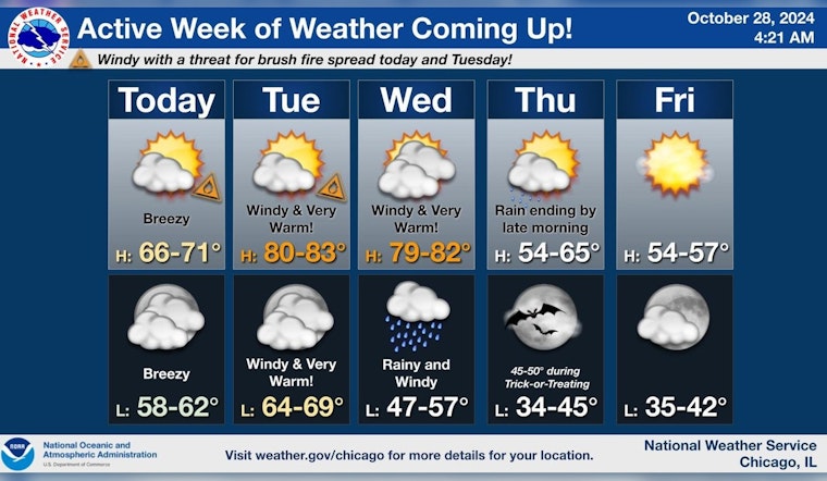
The city of Chicago is bracing for a dynamically active weather week, as the National Weather Service in Chicago/Romeoville, IL forecasted. According to the Hazardous Weather Outlook, residents can expect various weather conditions, including everything from gusty winds to the potential for heavy rains and thunderstorms. For today and tonight, the service has highlighted a limited fire weather risk due to dry conditions.
Beginning Tuesday, winds are forecasted to increase significantly, with gusts potentially reaching 40 to 50 mph coming from the south-southwest. This elevation in wind speeds coupled with the warmth and relative dryness of the region poses an elevated fire weather risk during the afternoon. Subsequently, those living in north central Illinois, northeast Illinois, and northwest Indiana should also be aware of these conditions, as stated in the weather forecast.
As the week progresses, the weather remains unsettled. The NWS has warned that Wednesday could bring the same elevated non-thunderstorm wind risks and has flagged a limited thunderstorm risk for the evening. The escalating winds aren't just a concern for those on the ground; marine interests will likely face gale-force winds, as mentioned in the hazardous outlook, necessitating caution and preparedness from those navigating the Illinois and Indiana nearshore waters of Lake Michigan.
Temperatures are also anticipated to fluctuate markedly throughout the week. The forecast promises a near-record warmth with highs reaching the low 80s by Tuesday but drops significantly to mid-50s by Friday. Rain is expected to intensify through the latter part of the week, potentially resulting in conditions ideal for rapid grass and brush fire spread beforehand. Thursday carries a 60% chance of showers mainly before 10 am, and by Sunday, the region is expected to experience more consistent rains, as emphasized in an update from the NWS Chicago.
A strong fall storm system will move across the country this week leading to increased threat for fire spread, near record warmth, gusty winds, and periods of soaking rain. Here’s a breakdown of what we are expecting, and when. #ILwx #INwx pic.twitter.com/YvJQPXtrXx
— NWS Chicago (@NWSChicago) October 28, 2024
Residents and visitors in Chicago and the surrounding areas are advised to stay informed and prepare for this active weather week. With potential impacts ranging from disruptive winds to fire risks and heavy rain, staying updated on forecasts and heeding advisories from the National Weather Service will be crucial for safety and preparedness during this period of fluctuating weather conditions.


