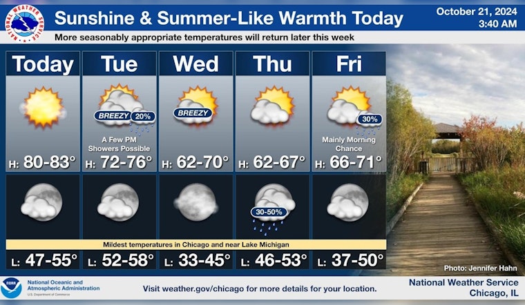
Chicago residents can enjoy a warm and sunny day today, with temperatures expected to reach the lower 80s, as reported by National Weather Service Chicago. The clear skies, however, are slated give way to a shift in weather over the coming days. Beginning on Tuesday, residents might want to keep an umbrella at hand with a 20 percent chance of showers after 1 pm, and gusts of wind that could reach as high as 30 mph.
Continuing through the week, Wednesday promises to be mostly sunny with a high near 65 degrees and northwest winds blowing at 10 to 15 mph. While the possibility of small craft having to navigate hazardous conditions on Tuesday and Wednesday has been highlighted by the National Weather Service, no other hazardous weather is expected from today through Sunday according to their Hazardous Weather Outlook.
As the week progresses, the NWS anticipates a turn towards more quintessentially autumnal weather. "A couple of breezy days are then in store for tomorrow and Wednesday, possibly a few light showers tomorrow, while temperatures become more fall-like by midweek," hinted the weather forecast posted on the NWS Chicago's social media. This transition may begin as early as Tuesday evening, which is expected to be mostly clear with lows around 57.
Temperatures today are expected to tap the lower 80s across the area with sunny skies. A couple of breezy days are then in store for tomorrow and Wednesday, possibly a few light showers tomorrow, while temperatures become more fall-like by midweek. #ILwx #INwx pic.twitter.com/yJI2L3uAp9
— NWS Chicago (@NWSChicago) October 21, 2024
The latter half of the week will see temperatures continue on a downward trend, with Thursday night introducing a chance of showers and lows around 51. Sunny days will persist into the weekend, with an expected high of 59 on both Saturday and Sunday, setting the tone for what appears to be a typical Chicago fall week, barring, any unexpected weather developments.


