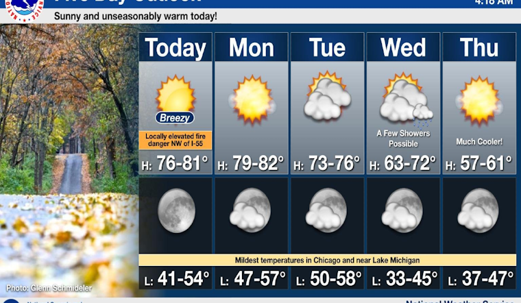
Chicago residents are currently basking in the warmth of an unseasonably sunny day, enjoying temperatures that have soared into the upper 70s, with the potential to hit the 80s in some areas, according to the National Weather Service (NWS). These summer-like conditions are set to continue through Monday, as mentioned in a detailed forecast. However, the NWS has issued a hazardous weather outlook warning of an elevated fire weather risk, particularly northwest of I-55 for the afternoon due to dry conditions and breezy southwesterly winds.
People enjoying today’s warmth should be aware that it will cool down later this week, with temperatures dropping to a high of only 59 degrees by Thursday. This outlook change was underscored by the forecast, with "sunny skies and summer-like temperatures" highlighted for Sunday, but a notably cooler "74 degrees" by Tuesday, as per information found on an NWS social media update. The NWS has also indicated that no hazardous weather is expected from Monday through Saturday, allowing Chicagoans to prepare and plan for the rapid shift in conditions.
Our Sunday will feature sunny skies and summer-like temperatures with highs in the upper 70s and even lower 80s likely in spots. A similarly warm day is in store for tomorrow before conditions begin to cool down into the latter part of the week. #ILwx #INwx pic.twitter.com/yra6FJVxAJ
— NWS Chicago (@NWSChicago) October 20, 2024
The rest of the week promises a mix of sun and potential showers, particularly on Wednesday, with a chance of 20 percent for rain showers in the forecast. Residents should also prepare for potentially hazardous conditions for small crafts on Lake Michigan come Wednesday and Thursday, taking into consideration the warnings provided for waterborne activities. The Hazardous Weather Outlook released by the NWS calls attention to these likely conditions, cautioning those with maritime interests to stay informed.
Lows at night will begin descending, from "a low around 54" tonight, edging down even further to "around 43" by Wednesday night, illustrating the NWS's forecast of a clear but cooler horizon.


