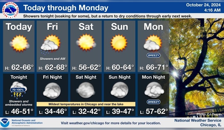
Chicagoans are bracing for a variety of weather conditions starting today and extending into next week. According to a detailed forecast from the National Weather Service's Chicago office, the city can expect sunny skies today with a high near 63 degrees, backed by a southsouthwest wind traveling at 5 to 10 mph.
The weather is set to change tonight, however, as there's a slight chance of showers, escalating to showers and possibly a thunderstorm after 1 a.m. Conditions are projected to deteriorate, with a 90% chance of precipitation and potential rainfall amounts between a quarter and a half of an inch. Localized patches of fog may also pose a limited risk early this morning, especially east of I-57 and across portions of northwest Indiana, as warned in the official forecast.
As for Friday, the city should prepare for more showers, mainly before 7 a.m., followed by partly sunny skies with a high again near 63. The south-southwest wind is expected to shift north-northwest in the afternoon, potentially gusting as high as 15 mph. The chance of precipitation dips to 60% with new rainfall amounts forecasted to be between a tenth and a quarter of an inch. The National Weather Service notes that "a system of showers and thunderstorms will move across the area late this evening into early Friday," stating that "while no severe weather is expected, periods of soaking rainfall are likely, especially near and north of I-80," according to their Hazardous Weather Outlook.
The weekend outlook then shifts to more favorable conditions; Saturday is anticipated to be sunny with a high near 57 degrees. The clear skies are to persist through Sunday night, with the National Weather Service forecasting a high near 62 on Sunday. Moving into early next week, Chicago will see partly sunny conditions on Monday with a high near 69, and by Tuesday temperatures are expected to soar to near 79 degrees, underscored by breezy conditions. Wednesday, however, could again bring a chance of showers with a partly sunny sky and a high near 76. These climactic fluctuations are important for residents to closely monitor and adjust their plans accordingly, as mentioned in a recent NWS Chicago post.
[4:20 AM 10/24] Showers and embedded thunderstorms arrive tonight, with a soaking rainfall for some, especially near and north of I-80. Dry conditions return into early next week with seasonable temperatures this weekend. #ILwx #INwx pic.twitter.com/mtQ2r4DL9V
— NWS Chicago (@NWSChicago) October 24, 2024
Mariners on Lake Michigan should also exercise caution; the National Weather Service indicates that "hazardous conditions for small craft are likely" on Friday, Saturday, Monday, and Wednesday. Moreover, Tuesday might bring gale-force winds into the equation, adding to the risks for those on the water. The details pertaining to local waters point towards a cautiously vigilant stance for any boating activities in the upcoming days.


