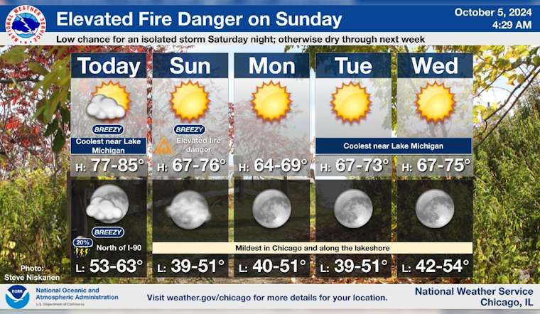
Chicagoans are weaving through a patchwork of weather over the next several days, bringing a mixed bag of sunny skies and potential weather hazards. According to the National Weather Service Chicago, the city will see "Mostly sunny, with a high near 80" today, accompanied by south-southeast winds pushing at 10 to 15 mph. Gusts could stretch their fingers up to an eager 25 mph.
Tonight's forecast casually flirts with the possibility of showers and thunderstorms between 2 am and 4 am, though with only a slight chance of precipitation. The low is predicted to dip around 62 degrees, while winds shift westward post-midnight, possibly reaching gusts as boisterous as 30 mph. Sunday’s weather seems more aloof with sunny conditions and a high near 72, but beware of the northwest wind's gusts reaching 25 mph which might sweep across the city.
A Hazardous Weather Outlook advanced by the National Weather Service warns of an "Elevated Fire Weather Risk" on Sunday. The culprits are the day's dry conditions and gusty northwest winds, which conspire to create kindling for potential grass and brush fires.
The forecast extends to the mariners with "Hazardous conditions for small craft" along the Illinois and Indiana nearshore waters of Lake Michigan being likely. An undercurrent of anticipation runs as "Limited Thunderstorm Risk" is in play tonight. Looking ahead, the city is to expect dry spells until next week, with only a low chance of an isolated storm north of I-90, according to NWS Chicago. Residents and authorities alike should remain alert, for the weather, much like the city's storied wind, tends to shift without much in the way of preamble.


