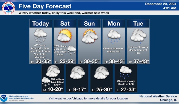
Chicago residents are bundling up as the city is in the midst of a three-part snow system that's bringing a second round of flurries and causing slick roads. Overnight snowfall added around an inch of coverage to the area, and the forecast from the National Weather Service indicates another inch could accumulate before Friday evening. With temperatures hovering around 30 degrees, expect a snowy blanket across the city, and gusts reaching 20 mph may bring an additional chill.
The ongoing snow event is predicted to make this morning's commute particularly cumbersome, especially for those in the northern regions where 2-3 inches of snow have already topped off the landscape. As reported by FOX 32 Chicago, "Round two of Chicago's three-part snow system is ramping up and moving in from the north." Gusty winds will accompany the falling snow, which could see a small accumulation of an inch or so, and temperatures are set to fall further once the system retreats.
The second wave of snow comes just before the lake-effect snow that's expected to touch northeast Illinois before shifting predominantly to northwest Indiana later today through Saturday. With the wind chill factor, it may feel like zero degrees tonight, as lows dip into the teens. The weekend promises colder temperatures but dryer days, with sunshine expected to peek through at times.
As Chicagoans look ahead, a much-needed respite from the cold snap is on the horizon. According to the National Weather Service, the real warmup hits next week with highs most days in the 40s and some small chances for possibly Monday morning then Christmas Day, and Thursday. This forecast offers a glimmer of hope that the city will thaw from its icy grip as the holiday season continues.
Until the rise in mercury, residents are urged to stay vigilant on the roads, dress warmly, and perhaps enjoy the winter wonderland from the comfort of their homes when possible.


