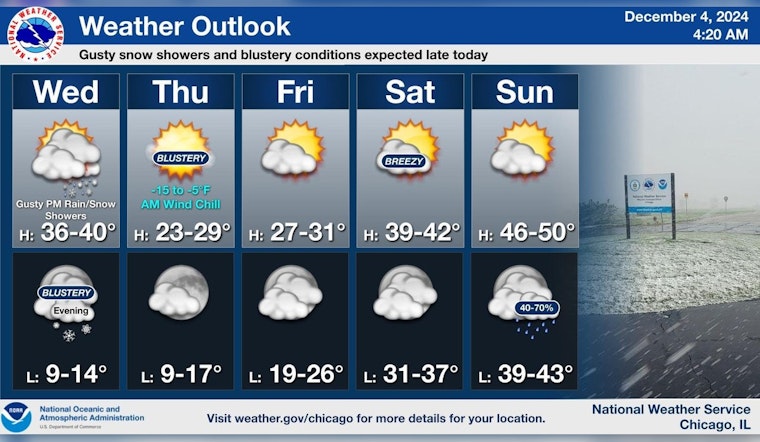
As the city braces for a blustery day ahead, Chicagoans can expect an assortment of weather patterns ranging from rain and snow showers to strong gusts that could reach up to 45 mph. According to a forecast from the National Weather Service, there is a 50% chance of precipitation with the potential for scattered rain and snow this afternoon transitioning to primarily snow after 4 p.m.
The rest of the evening, "Scattered snow showers before 10pm, then scattered flurries between 10pm and 11pm" are expected, as noted in the evening forecast. Additionally, residents should be prepared for "wind chill values as low as -4" degrees due to a blustery west-northwest wind persisting through the night.
In a separate report by FOX 32 Chicago, a wind advisory has been placed in effect from 2 p.m. until midnight today. Despite possible snowfalls, minimal accumulations are expected—the greater risk being temporary drops in visibility while snowflakes are descending. Temperatures are predicted to remain below the freezing point as the wind chill dips tonight.
Looking forward to the days ahead, Thursday promises mostly sunny skies though with "a high near 27" degrees, and wind chills potentially falling to -3 degrees. By Friday, a slight warm-up is anticipated with a high around 29 degrees. The weekend, however, will bring relief with temperatures climbing into the 40s, and Sunday's conditions even flirting with 49 degrees. The onset of the following week suggests a continuation of this pattern, with Monday harboring a chance of rain and highs nearing 49 degrees once again.


