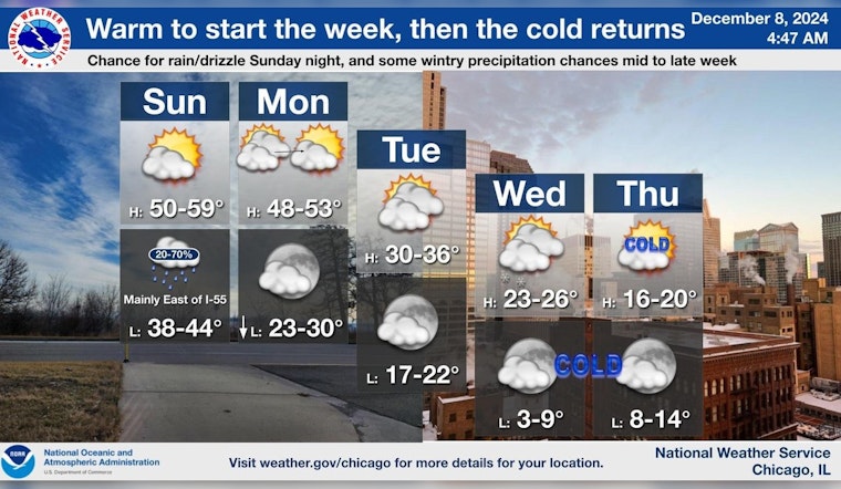
Chicagoans are embracing the brief respite from December's chill as mild temperatures persist into Monday, with the National Weather Service forecasting "mostly sunny" skies today and a comfortable high near 56 degrees; these conditions are set to prevail until a "chance of drizzle" enters the scene tonight after 9 pm, casting an increasing blanket of clouds over the city and holding steady temperatures around 46 degrees, according to their official website.
Similarly, CBS News Chicago indicates a trend towards "unseasonably warm" weather with Sunday highs cresting at 51 degrees, a stark contrast to typical December benchmarks, however as the week progresses, an imminent cold front is expected to sweep through, transitioning the warmth to "a brief Arctic chill" that'll impact the area from Tuesday through Thursday; thus reinforcing the city's reputation for "roller coaster temperature trends," as stated in their latest report.
The forthcoming weather shift, characterized by CBS News Chicago, brings an inevitable dip with Tuesday's high barely reaching 35 degrees and a stark low around 21 by nightfall, all under partly sunny skies that, despite the sun's modest endeavor, will struggle to fend off the impending cold that encroaches upon the city.
Heading into midweek, Wednesday threatens with "a chance of flurries with a slight chance of snow before noon," as detailed by the National Weather Service. At the same time, nightfall offers no respite with lows plummeting to a biting 8 degrees.
As Chicago experiences these fluctuating weather patterns, residents may find reassurance in the forecast of a gradual warming trend leading into the weekend. Temperatures on Friday are projected to approach 34 degrees, establishing the potential for precipitation characterized by unpredictability. As Saturday arrives, cloud cover is anticipated with a high temperature of approximately 42 degrees, indicating that the city's weather continues to exhibit a dynamic and ever-changing narrative.


