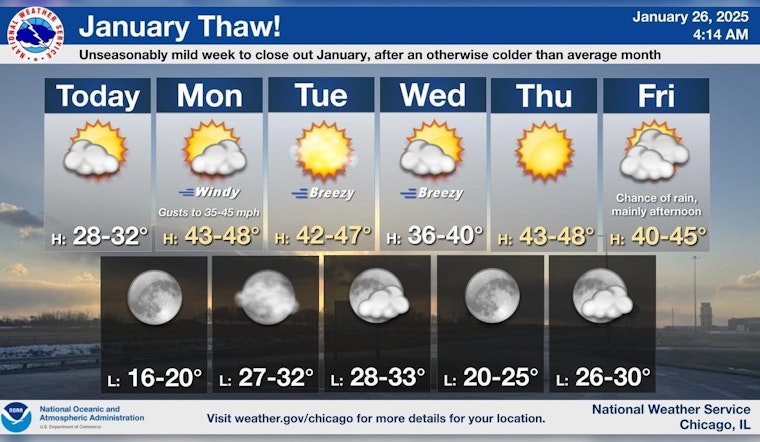
The city of Chicago is poised to experience a dance of temperatures over the upcoming week, starting with a bracing cold Sunday. According to CBS News Chicago, a cold front moved through the Chicago area on Sunday, resulting in temperatures that struggled to hit the upper 20s, coupled with wind chills expected to linger in the teens and lower 20s throughout the afternoon.
The frosty conditions, however, will not overstay their welcome. As per the narrative provided by the National Weather Service, Chicagoans can anticipate a high near 32 degrees under mostly sunny skies today. These temperatures hint at an incoming milder trend, with a forecasted climb to the high 40s kicking off as early as Monday amid strong, gusty winds.
The brief chills of Sunday are a prelude to a dramatic shift in weather patterns as the week progresses. Monday promises an increase in cloud cover, with the National Weather Service predicting "increasing clouds, with a high near 46." The Southwest winds are expected to pick up, reaching speeds of 25 to 30 mph in the afternoon with possible gusts as high as 40 mph.
Heading into Tuesday, the city will see mostly sunny conditions with a high hovering around 45 degrees. While the winds might ease slightly, they could still present gusts of up to 25 mph, according to the National Weather Service. This passage of mild weather seems to hold out for most of the week, with temperatures consistently in the 40s and conditions ranging from clear to partly cloudy.
However, towards the weekend, forecasts introduce the chance of rain, potentially mixed with snow on Friday night. The mercury is set to hover around the 40-degree mark, as CBS News Chicago notes, signaling an unsettled end to the week with a chance of rain come Saturday and a high near 41 degrees under mostly cloudy skies.


