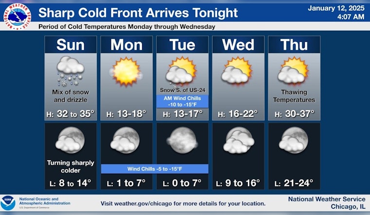
Chicago residents are bracing for a mixture of winter weather conditions and a looming deep freeze. According to an update from the National Weather Service, today's forecast includes drizzle, snow, and freezing rain likely before 3:00 p.m. followed by a slight chance of drizzle between 3:00 p.m. and 5:00 p.m. Commuters can expect a cloudy sky with high temperatures nearing 34 degrees and south-southwest winds reaching up to 25 mph. The day may see less than a half inch of snow accumulation, with little to no ice expected to build up.
The weather remains unsettled tonight as the sky is predicted to turn partly cloudy with lows around 13 degrees, creating wind chill values as low as 1. Winds persist at around 15 mph with gusts that may once again approach 25 mph. Following the snow, Chicago is set to experience an Arctic blast, detailed in a report from CBS News, which indicates the coldest time will be Tuesday morning, with wind chills to -15°.
Monday's outlook is notably clear, albeit with a bitterly high temperature of only around 18 degrees. Wind chill conditions could sharply drop to as low as -3. The evening is expected to maintain clear skies with a low near 7 degrees and wind chill diving deeper to as low as -8. As the week progresses, the city looks forward to a slight relief in conditions with sunny days although temperatures remain low, particularly on Wednesday with highs near 21 degrees.
A brief weather respite appears by Thursday, with partly sunny skies anticipated and temperatures climbing to a more tolerable high near 34 degrees. Thursday's night forecast will likely bring clouds back into play, with lows hovering around 25 degrees. Friday again presents a possibility for a mixed bag of conditions. "A chance of rain and snow" is expected according to the National Weather Service, with the day's temperatures aiming for highs near 37 and the overnight lows around 24.


