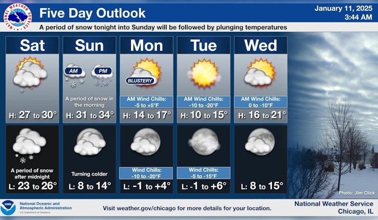
Chicagoans can expect isolated snow showers and scattered flurries this morning, transitioning to clouds and a high near 30 degrees. A report from the National Weather Service emphasizes a 20 percent chance of precipitation today with a change in wind direction from west-northwest to south-southwest later in the day. The same report suggests potential gusts as high as 20 mph by tonight, when the chance of snow increases to 30 percent, mainly after 4:00 a.m.
Looking forward, Sunday promises a 50 percent chance of a cocktail of drizzle, snow, and freezing rain throughout the day, with temperatures peaking at about 34 degrees and south winds at 15 mph, according to the National Weather Service. The onset of the workweek will usher in clearer skies, but with a high near 17 degrees on Monday, followed by a plunge to a low around 4 degrees on Monday night.
As reported by FOX 32 Chicago, after the evening commute, which could remain treacherous due to snowy and slick roadways, temperatures are anticipated to fall to the 20s by Saturday morning. However, most of Saturday should stay dry and partly sunny with a slight warming trend forecasted for the latter part of next week.
As the temperature takes a steep dive into the single digits on Monday night, conditions will remain very cold with sunny to partly cloudy skies on Tuesday and Wednesday. Yet, there's a hint of milder air on the horizon, as temperatures are expected to rise again toward the lower 30s by next Thursday, and possibly climb further, into the upper 30s by Friday.


