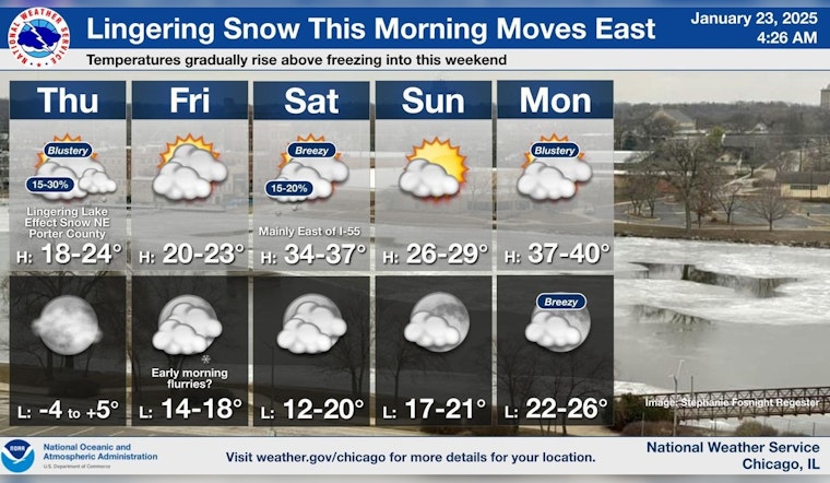
The city of Chicago woke up to snow this morning, with the flurries expected to temper off before the late morning. According to the National Weather Service, the likelihood of precipitation stands at 70%, though total daytime snow accumulation is anticipated to be less than half an inch. As the day progresses, skies will clear up somewhat, but the temperature will drop to around 18 by 9 am, accompanied by northwest winds ramping up to speeds of 15 mph, with possible gusts reaching 25 mph.
Steady low temperatures in the low 20s are expected to hold throughout the day following the snow's cessation, as reported by FOX 32 Chicago. Tonight's conditions will veer towards the more extreme side, with the forecast predicting lows plummeting into the single digits and wind chill values potentially falling as low as -8. In some isolated areas, temperatures might edge below zero.
Looking ahead, Friday's forecast suggests a trend of increasing clouds with highs hovering near 21 degrees and wind chill values that could dip to -9. This instance of colder than usual weather will persist into the night though flurries may appear after midnight. Meanwhile, Saturday offers a gentle respite with an expected high near 36 degrees, and sunny skies will likely dominate the weekend forecast.
Weather patterns early next week are poised for a slight shift, introducing a milder atmosphere. Monday is set to welcome mostly sunny conditions and temperatures that could rise to a more agreeable 39 degrees, breezy though it may be. As the week unfolds, the highs are likely to stay above freezing, inching into the 40s, as mentioned by FOX 32 Chicago. This gentle warming suggests a possible melting of the existing snow cover, gradually ushering in a semblance of early spring.


