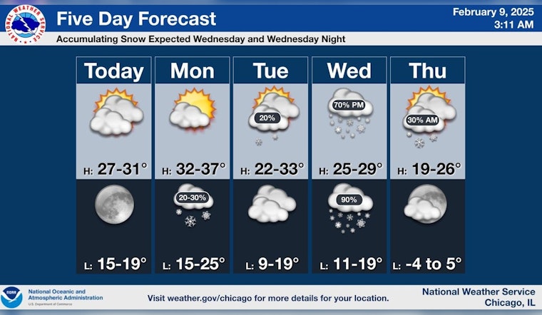
As Chicago residents revel in a partly sunny Sunday, with the mercury hovering just below the freezing mark, whispers of the week ahead prompt a mixture of anticipation and preparation. With an eye on the skies, meteorological sources provide a glimpse into the near future, starting with today's forecast by the National Weather Service that calls for "scattered flurries before noon" and a high near 30. The west wind will breeze through at 5 to 10 mph, with possible gusts reaching 15 mph.
The night promises to bring mostly clear skies, with a low around 20 and a soft west wind sticking around 5 mph. Looking forward, Monday is expected to invite increasing clouds, with a high inching up to near 34 before a northerly shift in the winds in the afternoon, according to the same source.
Meanwhile, a separate forecast from CBS Chicago echoes the sentiment for a "quiet day" today, with "partly sunny skies, with temperatures a bit colder" than Saturday's high of 33. The report also takes note of an impending snow event saying, "The next event we're closely tracking is snow for Wednesday into Thursday, which could give us an accumulation that'll need to be shoveled."
Indeed, there's a palpable shift in the briefing as we approach midweek. National Weather Service forecasts show a potential for snow, that gently reminds the city of winter's reach, with a 60% chance of precipitation on Wednesday and continuing flurries into Thursday. As temperatures dip once more later in the week, Thursday night promises a sharper cold, sinking to around 5 degrees.
Residents might find solace in a slight warm-up by Saturday with snow likely, cloudy skies, and a high near 33, capping off a week dominated by winter's whims.


