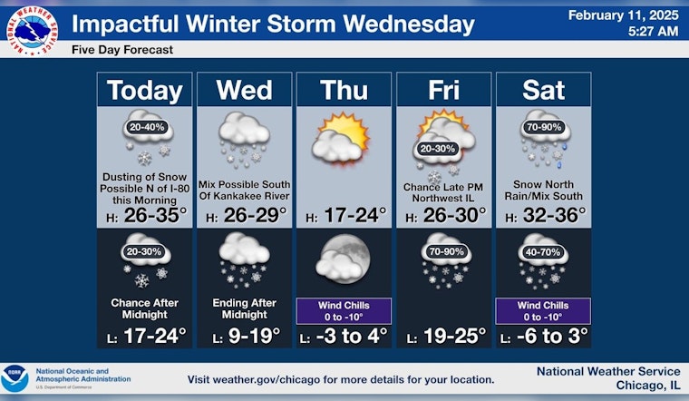
Brace yourselves, Chicagoans, for a blast of winter is about to make its presence felt across the region, bringing a significant snowfall that's likely to affect your midweek commute. According to the National Weather Service, today's dreary skies with a chance of snow flurries will see a high near 30 degrees, with winds gusting up to 20 mph. But the main event comes on Wednesday when a solid wall of white is set to descend upon Chicago, with heavy snow forecasted and total accumulations between 3 to 7 inches during the day, and an additional 2 to 4 inches at night.
The weather outlook suggests a 100% chance of snow on Wednesday, it could be heavy at times, an advisory made more pressing by an impending Winter Storm Watch issued for a wide swath of counties including Cook, DuPage, and Lake. This warning stretches from 9 a.m. Wednesday until 3 a.m. Thursday, prompting concerns for the evening rush hour when the heaviest snowfall is predicted to make its weight felt precisely when workers are making their way home.
"Heaviest snow will come during the evening rush hour, between 3-9 p.m., with snow winding down around midnight," ABC7 AccuWeather Meteorologist Tracy Butler forecasted. While tonight's low hovers around 25 degrees, Thursday will usher in a plunge of polar air, bringing bitter cold and wind chills dropping to -5 degrees.
Looking ahead, skies will clear up on Thursday with mostly sunny conditions, and the mercury will struggle to hit a high of 22, and drop to a low of around 4 degrees at night, following this week's tempest. We are looking at partly sunny skies for Friday with snow returning Friday night into the weekend, and as we gaze further, snow is likely on Saturday, with probabilities lingering through to Sunday.


