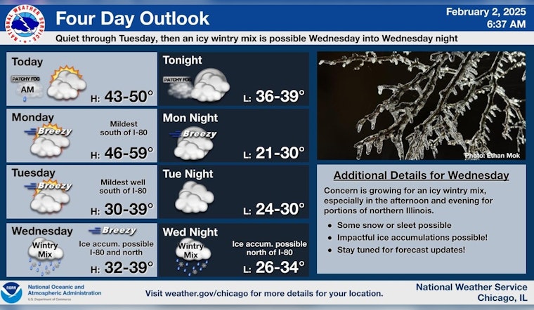
Chicagoans are bracing themselves for a slight change in weather as a light wintry mix is expected to sweep through the area overnight. According to the National Weather Service, there's a slight chance of a drizzle before 10:00 a.m. today with patchy fog preceding a mostly cloudy day and temperatures inching near 44 degrees. As the evening beckons, there's a forecast of patchy fog after midnight, and then a largely uneventful transition to mostly cloudy skies with lows hovering around 38.
Tonight, as mentioned by Fox 32 Meteorologist Mark Strehl, a light wintry mix might make its presence felt with little to no snow accumulation. However, it should be noted that the roads may still become slippery. Come Sunday morning, the wintry conditions are expected to clear up, paving the way for a breezy day with strong winds and higher temperatures in the upper 40s.
The week ahead will continue with Chicago experiencing a mix of cloudy skies and peaks of the sun. Monday's weather is said to mirror today's, starting with patchy fog before shifting to mostly cloudy skies with highs near 50 degrees and gusty winds that could reach up to 20 mph, as the wind direction shifts north in the afternoon. The temperatures are projected to dip to around 29 degrees Monday night under mostly cloudy conditions.
As we move through the week, the uncertainty of Midwest weather continues to play out. "Rain, snow and sleet likely, possibly mixed with freezing rain after noon," says the National Weather Service about Wednesday's forecast. They report a 60% chance of precipitation and cloudy skies with highs near 35. The evening could see rain likely mixed with freezing rain before midnight, then there's a chance of rain, snow, and possibly more freezing rain with lows about 31. The latter portion of the week suggests partly sunny conditions but there's potential for a return of snow and overcast skies by the weekend.
Residents are encouraged to stay updated on weather conditions as the week progresses.


