The National Weather Service in Indianapolis is forecasting a variety of weather conditions for central Indiana over the coming days, with scattered showers and thunderstorms anticipated. According to the NWS latest update, the chance of precipitation today is 30%, with thunderstorms mainly expected after 4 pm. The temperature is set to climb, reaching a high near 83°F, and winds are predicted to be calm, shifting south southeast at around 6 mph in the afternoon.
As evening approaches, the chance of scattered showers and thunderstorms drops slightly before 2 am, with isolated showers continuing intermittently through the early morning hours. The overnight low will hover around 61°F, accompanied by a light south southeast wind. Friday presents an increased probability of wet weather, with the likelihood of showers and thunderstorms rising to 80%, as reported by the National Weather Service.
Looking ahead to Friday night, the forecast shows an ongoing threat of showers and thunderstorms before 11 pm, eventually giving way to likely showers till about 2 am. Temperatures are expected to dip to around 48°F, with winds shifting from southwest to north northwest post-midnight. Over the weekend, conditions will improve with partly sunny skies and a peak temperature of 63°F on Saturday.
For those planning outdoor activities, Sunday promises sunny weather with a comfortable high near 68°F. The positivity extends into Monday, boasting mostly sunny skies and a max temperature near 80°F. However, there's a 20 percent chance of showers after 2 am leading into early Tuesday, where showers are likely, and possibly a thunderstorm, as per the NWS' latest detailed forecast. Central Indiana residents should keep an eye on weather updates heading into next week, especially on Tuesday, as the possibility of severe weather looms on the horizon.
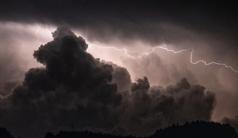
The National Weather Service has issued a hazardous weather outlook for the region, urging spotters to closely monitor forecasts for next Tuesday, when a few storms could turn strong. Lightning, the natural electrical discharge of a very short duration and high voltage, poses a risk with any storm that develops, while the overall situation holds a degree of uncertainty for severe weather potential. The public can access further weather, hydrological, and climate information through the NWS' official website.


