

























































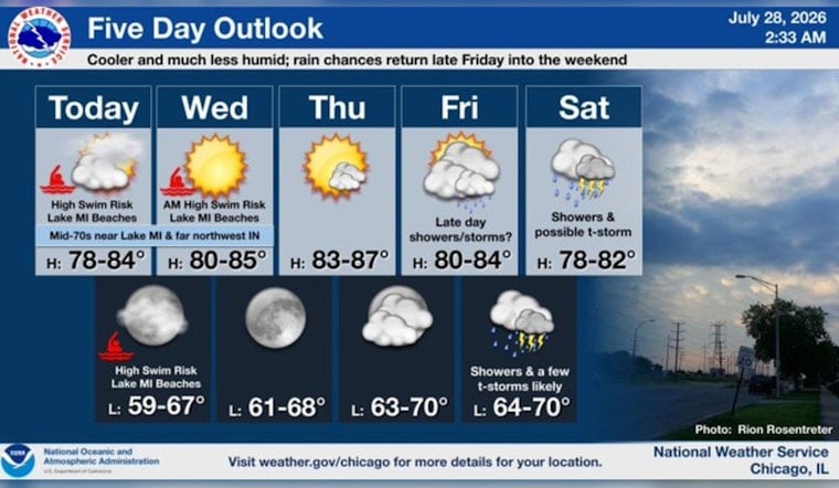
Chicago woke up under a blanket of gray on Tuesday, July 28, 2026, with temperatures hovering around 70°F at Midway and a stiff north wind already muscling in off the lake. The high is expected to top out near 73°F, but the real headline is the wind, with gusts forecast to reach up to 30 mph. That combo is churning up Lake Michigan and turning the shoreline into a hazard zone. Lifeguards and parks officials are urging swimmers to stay out of the water and to steer clear of piers, breakwalls and other shoreline structures while advisories are posted. If you were banking on a beach day, plan to move things inland or punt those plans to Wednesday morning, when conditions are expected to ease.
Afternoon Winds Pick Up
Through the afternoon, north winds are expected to hold steady around 15 to 20 mph, with frequent gusts hitting the 25 to 30 mph range, especially along the lakefront. Those bursts can make driving high-profile vehicles a bit dicey and will kick up sand and small debris along shore-side paths. According to National Weather Service Chicago, the gusty pattern will continue into the evening, with occasional stronger gusts possible overnight.
Lakefront Safety
The Park District relies on a flag system and daily water checks to decide when to issue swim advisories or bans, so beachgoers should always check the flags, call 312-74BEACH, or visit the district’s beach guide before heading anywhere near the water. Lifeguards are responsible for enforcing swim bans and will shut down swimming areas when conditions turn dangerous, so do not assume that a crowded beach means it is safe to jump in. The Park District site posts daily test results and current advisories for every public beach.
Beach Hazards Statement In Effect
The National Weather Service has issued a Beach Hazards Statement for the Illinois and Indiana shores of Lake Michigan through Wednesday morning, July 29, 2026, warning of high wave action and dangerous currents, with waves building to 7 to 11 feet. A Small Craft Advisory is also in place for nearshore waters until 7 AM CDT Wednesday, July 29, 2026. The NWS is blunt about it: stay out of the water and off piers and breakwalls while the statement is in effect. For official details and the latest updates, see National Weather Service Chicago.
Looking Ahead
Once this cool, blustery stretch moves out, temperatures are set to bounce back later in the week. Thursday, July 30, 2026, is expected to turn warm, with highs near 86°F, before the next system brings rain chances Friday into Saturday. The best bet for showers and thunderstorms is Friday night into Saturday, August 1, 2026. For more background on the recent heat and storm setup from Monday, see Chicago stuck in a steam bath. Keep an eye on updated forecasts if you are banking on outdoor plans for the long weekend.





