

























































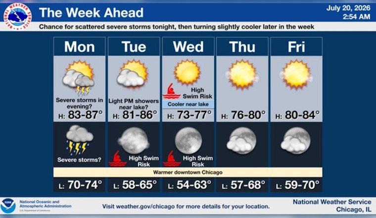
Monday, July 20, 2026 — Chicago woke up to a smoky, hazy start, with temperatures near 68°F at Midway and a sky that looked more like late August than mid-July. Afternoon highs are expected to climb to about 86°F, with south-southwest breezes of 5 to 15 mph and gusts that could hit 30 mph. The smoke should thin from southwest to northeast through the morning, while a few isolated showers or thunderstorms could pop up between 10 a.m. and 1 p.m. The main story, though, arrives after sunset, when scattered storms after 7 p.m. could bring brief heavy rain and some punchy wind gusts.
Air Quality Alert and Health Advice
The Illinois Environmental Protection Agency and the National Weather Service have declared an Areawide Air Pollution Action Day for Monday, with fine particulates expected to push the local Air Quality Index into the “Unhealthy for Sensitive Groups” category. The Air Quality Alert is in effect through midnight CDT. The Illinois EPA advises people with asthma, chronic lung disease, older adults, and children to keep outdoor exertion on the light side. If you start coughing or feel short of breath, shift activities indoors and keep quick-relief medication close by.
Afternoon Winds and Timing
The thickest smoke should drift northeast through the morning, which means early commuters get the worst of the murky views. As the day wears on, south-southwest winds will pick up and turn the afternoon breezy, which may keep some particulates lofted even as the overall haze thins. Isolated showers and thunderstorms are on the table from about 10 a.m. to 1 p.m. on Monday, July 20, but the better chance for more organized showers and storms holds off until later in the day.
Tonight into Tuesday
Scattered showers and thunderstorms are most likely after 7 p.m. Monday, with roughly a 50% chance of rain overnight and southwest winds near 15 mph plus gusts up to 30 mph. New rainfall totals should be light, generally under a tenth of an inch, although any one storm could briefly knock down visibility and kick out some strong gusts. Tuesday looks to stay breezy and a bit hazy, with highs near 85°F and yet another round of scattered storms possible.
What to Do
Keep outdoor plans loose. Shorten or move strenuous activities indoors, close windows if the smell of smoke is noticeable, and use an air purifier if you have one. Anyone with heart or lung conditions should carry medications and follow their action plans, and it is worth a quick check of local AQI readings before heading outside. With gusty afternoon winds and the chance of fast-hitting evening downpours, secure lightweight outdoor items and take it slow on the roads if visibility drops.





