

























































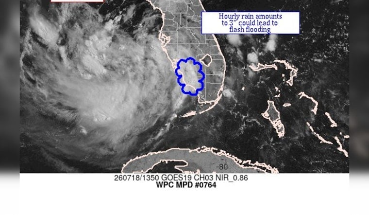
Southwest Florida is staring down some serious soakers, as federal weather watchers flag a short-term heavy-rain threat that could flip the switch from dry pavement to flash flooding in a hurry. Forecasters say slow-moving thunderstorms may unload intense downpours in tight, narrow bands, with localized hourly rain totals approaching 3 inches in the strongest cells. That kind of rapid-fire rain can turn low-lying neighborhoods, poor-drainage corridors and busy urban streets into fast-forming flood zones.
According to NWS Miami, the Weather Prediction Center's MetWatch desk issued Mesoscale Precipitation Discussion #0764 for "Southwest FL," warning that hourly totals could approach 3 inches and that "flash flooding possible." The MPD is a short-term product used to alert local forecast offices and emergency managers about where pulse thunderstorms may drop very heavy rain in a short window. The MPD text and graphic are posted on the WPC MetWatch page.
What Forecasters Mean
Flash flooding from these pop-up pulse storms can develop in minutes and often hits the spots least able to handle it: small streams, canals and urban streets with poor drainage. The National Weather Service leans hard on its familiar safety message, "Turn Around, Don't Drown," and notes that even a few inches of moving water can be enough to sweep a vehicle off the road. The agency's flood-safety guidance urges residents in vulnerable areas to be ready to move to higher ground quickly if water starts rising.
How To Stay Updated
For the latest discussion and any follow-up flash-flood warnings, keep an eye on the WPC MetWatch listings and your local National Weather Service office. Local forecast offices such as NWS Tampa Bay and NWS Miami will issue watches or warnings for their counties, and NOAA Weather Radio or county emergency channels will carry the most urgent alerts. It is a good day to keep phones charged and to skip any travel through flooded roadways while storms are firing.
If you are in Southwest Florida this afternoon, plan for sudden, intense downpours and avoid driving through standing water. We will update this post as local offices publish warnings and more details become available.





