

























































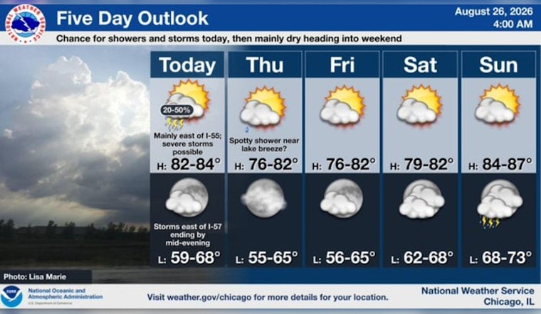
Chicago is waking up mostly cloudy and near 70 degrees Wednesday, August 26, with a messy forecast ahead. Scattered showers and thunderstorms are possible this morning, followed by a more serious storm window from afternoon into early evening as temperatures climb near 84 degrees.
Storm Risk Rises This Afternoon
Morning showers and isolated storms may fade or weaken, but additional storms could redevelop as a cold front moves across the region. The greatest severe-weather potential is south and east of a Paxton, Illinois, to Valparaiso, Indiana, line, with damaging winds and hail the main concerns if stronger storms form.
For Chicago, rain chances remain in the 20% to 30% range, so Wednesday is not expected to be an all-day washout. Still, lightning and quick downpours could complicate afternoon commutes or outdoor plans, while west-southwest winds of 10 to 15 mph may gust as high as 25 mph, according to the National Weather Service Chicago.
The timing is a sharper, more immediate update to the midweek storm pattern outlined in an earlier Hoodline forecast. No watches, warnings, or advisories are listed in the current report, but storm conditions can change quickly during the afternoon window.
Thursday Brings A Cool Reset
Once the front clears, Wednesday night should turn mostly clear with a low around 67 degrees and lighter northwest winds. Thursday looks like the reward: sunny, cooler, and near 76 degrees, followed by another sunny 76-degree Friday.
Weekend Warms Back Up
Saturday should be mostly sunny near 81 degrees, but summer warmth returns Sunday with a high around 86 under partly sunny skies. Shower chances creep back in Sunday night, with additional low-end storm chances Monday and Tuesday as highs remain in the mid-80s.





