

























































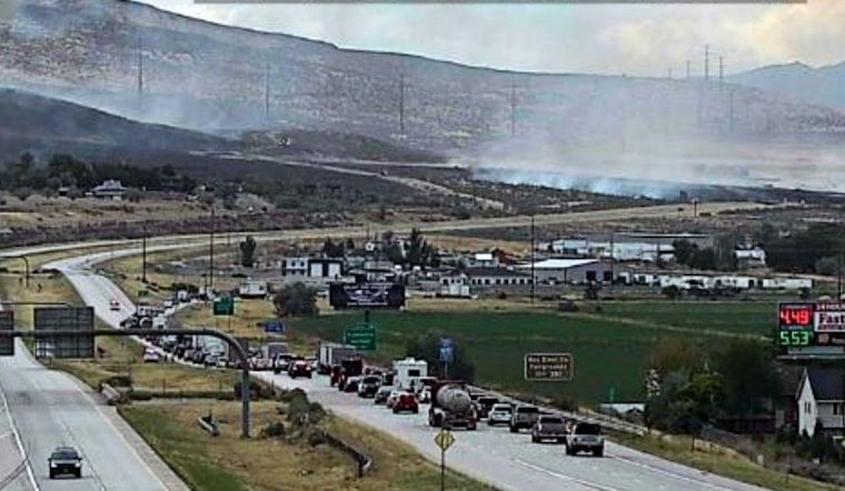
A fast-moving grass fire tore through rural land north of Tremonton and west of Garland Friday evening, growing from an initial estimate of 75 acres to as much as 300 acres in a matter of hours as gusty winds pushed flames toward homes, power lines and Interstate 15. The Garland Fire Department ordered an evacuation for all Harley Drive residents as the blaze, now known as the Harley Fire, threatened structures, water systems and roadways in the area.
By 5:50 p.m. on Friday, the Garland Fire Department had revised its size estimate for the Harley Fire to between 200 and 300 acres, according to Gephardt Daily, as wind-driven flames rapidly outpaced the initial 75-acre estimate reported by Utah Fire Info. KSL.com reported that Utah Fire Info had flagged structures and critical infrastructure as being under threat, and the agency advised nearby residents to avoid the area entirely while crews worked the scene.
The Garland Fire Department was on scene battling the blaze as it pushed toward Interstate 15, Utah's main north-south corridor through the region. Transportation officials shut the freeway down in both directions between mile markers 381, near the Tremonton and Garland exit, and 385, near the Riverside exit, after heavy smoke created near-zero visibility and flames crept close to the roadway. Southbound lanes were the first to close around 5 p.m. before crews diverted northbound traffic as well, per the same Gephardt Daily report.
Evacuations and a Shelter at the Armory
Garland City Emergency Management opened an Emergency Operations Center and a public shelter at the Garland Armory Friday evening to house residents forced from their homes. Utah Fire Info urged Garland residents to follow local officials' instructions and to evacuate immediately if told to do so, underscoring how quickly conditions were shifting on the ground.
While Harley Drive residents were placed under mandatory evacuation orders, fire officials also moved the neighboring Radio Hill area into what's known as “Ready Status,” the baseline tier of Utah's Ready, Set, Go! evacuation framework that tells residents to prepare emergency supplies in case winds shift and orders expand. In addition to the interstate shutdown, emergency management closed Canal Road, also known as 7600 West, to through traffic to keep rural roadways clear for fire apparatus and drone operators working the fire from the air.
Crews Race an Incoming Storm
Late Friday, crews with Utah Forestry, Fire & State Lands built a dozer line around the fire's perimeter, clearing vegetation down to bare dirt in an effort to hold the blaze ahead of an incoming storm system, according to a Facebook update from KUTV meteorologist Heidi Hatch. The tactic was aimed at blocking embers that erratic thunderstorm winds could otherwise carry across containment lines.
The Harley Fire ignited less than 24 hours after another blaze, the 560-acre Little Mountain Fire, broke out west of Bear River City in Box Elder County, threatening haystacks and forcing a local landfill closure, as Hoodline previously reported. Box Elder County crews were still working to secure that fire when the Harley Fire erupted, stretching local firefighting resources across two active incidents at once.
A Brutal Month for Box Elder County
Earlier in August, Box Elder County emergency agencies were already managing the 6,889-acre Johnson Canyon Fire north of Tremonton, which forced Level 1 evacuation warnings for the towns of Portage and Washakie, according to Box Elder County. Within a three-week span, the county has now faced three significant wildfires — Johnson Canyon, Little Mountain and Harley — a pace that has tested mutual-aid agreements, local water resources and county emergency management capacity.
The cluster fits into a wider pattern across Utah this year. Through late August, the state had recorded 879 wildfires that burned more than 537,000 acres, making 2026 one of the most destructive wildfire years on record with more than 200 structures lost statewide, according to KTVX-TV ABC 4. Human activity caused roughly half of those fires. The season's single most destructive blaze was the Cottonwood Fire in Beaver County, which burned more than 93,000 acres and destroyed roughly 184 structures, offering a stark benchmark even as grass fires like the Harley Fire threaten local utilities rather than mass structure loss.
As of Friday evening, the Harley Fire remained active, with crews continuing to monitor winds and the incoming storm system that could complicate containment efforts. This story will be updated as new information becomes available.





