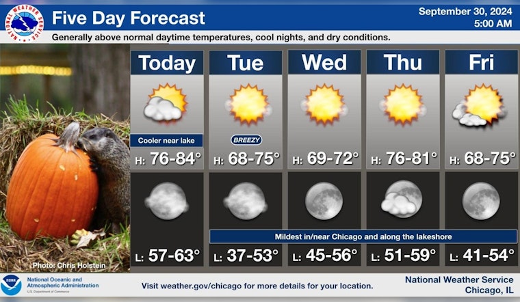
Chicagoans can prepare for a spell of pleasant weather as a mostly sunny sky with highs in the mid-70s sets the stage today, according to the National Weather Service. Moving into the evening, the forecast anticipates a transition to partly cloudy skies while holding onto mild temperatures, hovering around the low 60s.
The serene palette of blue skies carries on into Tuesday; however, a cool breeze is set to sweep across the city, reaching up to 30 mph gusts, following a cold front, the weather service reports that although today and tonight show no signs of hazardous conditions, come Tuesday, an "Elevated Fire Weather Risk" arises due to the dry and windier atmosphere, dry and breezy conditions behind a cold front on Tuesday will result in an elevated risk for brush fires the Hazardous Weather Outlook advises cautiousness.
Midweek expectations frame a sunny Wednesday with mild winds and temperatures maintaining a cozy feel close to the 70-degree mark, in alignment with the forecast which promises a "mild to warm by day and cool overnight" climate—ideal for those early autumnal outdoor activities, as shared by NWS Chicago.
An extended period of quiet weather is in store through the work week. It will be mild to warm by day and cool overnight, particularly Tuesday night into early Wednesday. #ILwx #INwx pic.twitter.com/qVquls8DWF
— NWS Chicago (@NWSChicago) September 30, 2024
Continuing through the rest of the week, Chicago sees consistency in its weather pattern, featuring mostly clear nights with lows in the mid-50s and daily highs progressive warming towards the weekend reaching a comfortable upper 70s, Friday specifically presages a mostly sunny day aligned with a "clear" night maintaining a low around 53 degrees.


