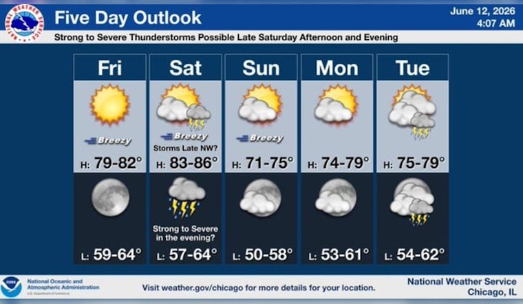
Chicago woke up to mostly clear skies and cool lake air Friday morning, June 12, 2026, with temperatures near 62°F downtown. The sun is expected to take over quickly, setting up a bright but breezy day before a stormier weekend muscles in. West winds will increase through the afternoon and keep lakefront neighborhoods a bit cooler than spots farther inland.
Afternoon Winds Pick Up
Under plenty of June sunshine, highs should reach near 80°F Friday, with west winds of 10–15 mph and gusts up to 25 mph during the afternoon. Tonight is forecast to stay mostly clear with a low around 65°F, ahead of a warm Saturday with a high near 85°F and southwest winds around 10–15 mph. A cold front is expected to sweep through Saturday night, bringing a high chance of showers and thunderstorms into the overnight hours, according to the National Weather Service.
Storm Timing And Weekend Impacts
Scattered storms are most likely Saturday afternoon and especially Saturday evening into the night (June 13), when any stronger cells could bring heavy rain, hail and damaging gusts. The greatest severe threat is forecast a bit farther southwest, but timing and storm tracks are uncertain enough that parts of the Chicago metro could still see intense downpours and short-lived power outages. Earlier rounds of severe weather this week knocked down branches and led to a ground stop at O'Hare, a reminder that travel and outdoor plans may again be disrupted, according to NBC Chicago.
What To Know For Weekend Plans
If you have Saturday night plans, build in a weather backup: secure patio furniture, move events earlier if possible, and have a quick route indoors for concerts or festivals. Sunday should be cooler with highs near 76°F and any leftover showers ending by midday, setting up a drier afternoon. Keep an eye on local alerts and the National Weather Service for updates before traveling or heading to large outdoor gatherings.


