Chicago is sliding into one of those classic Midwestern weeks where the umbrella and water bottle both earn their keep. Forecasts call for rain or showers every day through Thursday, with a midweek warm-up that could push afternoon highs into the low 90s and drive heat-index readings into the upper 90s in some neighborhoods. Outdoor plans might need a Plan B, and any slow-moving storm could dump enough water to trigger quick urban flooding.
Rain and storms locked in through Thursday
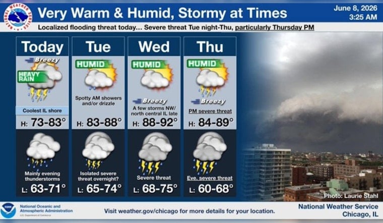
The National Weather Service is calling for rain and a chance of thunderstorms each day through Thursday across the Chicago metro area. Forecasters caution that repeated or "training" storms could pass over the same spots, dropping heavy rain in short bursts and boosting the risk of localized flooding on streets and in low-lying areas.
Storm timing and localized flood risk
Storms are expected to move into the region Sunday afternoon, with some capable of producing "torrential downpours and flooding" in isolated locations, according to Block Club Chicago. That report also notes that Tuesday and Wednesday each carry roughly a 20 percent chance of thunderstorms. So, most neighborhoods may stay dry at any given time, but any storm that does pop up could be intense and briefly drench whoever is unlucky enough to be under it.
Heat builds in for the middle of the week
The warm-up starts Tuesday, when highs climb into the upper 80s and then into the low 90s for both Wednesday and Thursday, according to FOX 32 Chicago. Humidity will pile on, and that muggy air will push "feels like" readings into the upper 90s later in the week, NBC Chicago reports. Anyone sensitive to heat, or planning to be outside for long stretches, should be ready to slow down, find shade and drink plenty of water.
Cooler, calmer days on the horizon
A cold front is expected to sweep through Thursday night and bring in cooler, less humid air for the weekend, according to the National Weather Service. Friday and Saturday are projected to be sunnier and more comfortable. Until then, keep an eye on alerts, skip driving through standing water during any downpours and treat Wednesday and Thursday like midsummer: light clothing, lots of hydration and frequent breaks from the heat.


